Page 459 - Geosystems An Introduction to Physical Geography 4th Canadian Edition
P. 459
 now
geosystems
Human-Caused Scarification in the Athabasca Region of Alberta
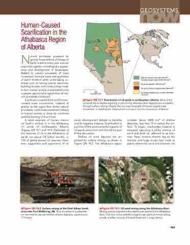
Natural processes powered by gravity move billions of tonnes of earth material every year and are important agents controlling the appear- ance and development of landscapes. Added to natural processes of mass movement, humans move vast quantities of earth material while undertaking ac- tivities such as mining natural resources, building houses, and constructing roads. In fact, human activity is estimated to be a greater geomorphic agent than all nat- ural processes combined.
Scarification results from such human- caused mass movements. Instead of gravity as the agent that drives natural processes, most mass movement related to human activity is done by machines and the burning of fossil fuels.
A stark example of human impact on earth’s surface is in the Athabasca oil sands of northeastern Alberta (Figures GN 14.1 and 14.3). estimates of the reserves of oil in the Athabasca oil sands are about 174 billion barrels, or 13% of global proven oil reserves. How- ever, supporters and opponents of oil
Peace River deposit
Jasper
Fort McMurray
Athabasca deposit
Edmonton
Banff Calgary
Cold Lake deposit
      0
200 KILOMETRES
Alberta’s boreal forest (381 000 km2) Canada’s boreal forest (3 200 000 km2)
Oil sands deposits (142 200 km2)
Oil sands surface mineable area (4800 km2)
Oil sands mineable area currently disturbed (715 km2)
▲Figure GN 14.1 Distribution of oil sands in northeastern Alberta. Most of the oil sands lies at depths requiring in situ mining, whereas other deposits are accessible through surface mining. Clearly, this is a major example of human-caused mass movement, or scarification. [Adapted with permission from the Government of Alberta.]
sands development debate its benefits and its negative impacts. Scarification is justoneoftheenvironmentalimpactsof oil-sands extraction and should be part of this discussion.
Shallow oil sand deposits are ex- ploited by surface mining, as shown in Figure GN 14.2. The Athabasca region
includes about 4800 km2 of shallow deposits, less than 75 m below the sur- face.Tobegin,overburdenmaterialis stripped, exposing a sticky mixture of sand and thick oil, referred to as bitu- men. Next, massive shovels dig up the mixture and huge trucks haul loads to plants where the sand and bitumen are
    ▲Figure GN 14.2 Surface mining at the Shell Albian Sands mine near Fort McMurray, AB. Tens of metres of overburden are removed to expose shallow oil sand deposits. [Jay McIntosh/ CP Images.]
▲Figure GN 14.3 Oil sand mining along the Athabasca River. Mining activity adjacent to the dark-brown waters of the Athabasca River. This true-colour satellite image shows open-pit mines, tailing ponds, and the removal of boreal forest. [eO-1 image, NASA.]
423


