
Page 473 - Geosystems An Introduction to Physical Geography 4th Canadian Edition
P. 473
Chapter 14 Weathering, Karst Landscapes, and Mass Movement 437
▲Figure 14.16 Buraco das Araras, a solution sinkhole near Goiás, Brazil. [Joeo Guilherme de Carvalho/Getty Images.]
Karst Valleys Through continuing dissolution and col- lapse, sinkholes may coalesce to form a karst valley—an elongated depression up to several kilometres long. Such a valley may have bogs or ponds in sinkhole depressions and unusual drainage patterns. Surface streams may even “disappear” to join the underground water flow typical of karst landscapes; disappearing streams may join subsurface flows by way of joints or holes linking to cavern systems or may flow directly into caves.
The area southwest of Orleans, Indiana, has an av- erage of 390 sinkholes per km2 (see Figure 4.18). In this area, the Lost River, a disappearing stream, flows from the surface into more than 13 km of underground solu- tion channels before it resurfaces in a spring, or “rise.” The Lost River’s dry channel can be seen on the lower left of the topographic map in Figure 14.18d. The Orangeville Rise near Orleans is the second largest spring in Indiana (Figure 14.18e).
tropical Karst In tropical climates, karst topography includes two characteristic landforms—cockpits and cones—with prominent examples found in the Carib- bean region (Puerto Rico, Jamaica) and southeast Asia (China, Vietnam, and Thailand). Weathering in these wet climates, where thick beds of limestone are deeply jointed (exposing a large surface area for dissolution
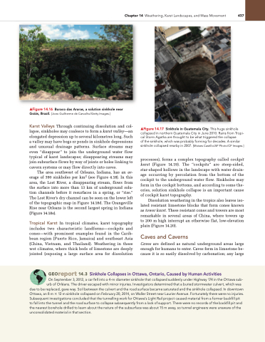
▲Figure 14.17 Sinkhole in Guatemala City. This huge sinkhole collapsed in northern Guatemala City in June 2010. Rains from Tropi- cal Storm Agatha are thought to be what triggered the collapse
of the sinkhole, which was probably forming for decades. A similar sinkhole collapsed nearby in 2007. [Moises Castillo/AP Photo/CP Images.]
processes), forms a complex topography called cockpit karst (Figure 14.19). The “cockpits” are steep-sided, star-shaped hollows in the landscape with water drain- age occurring by percolation from the bottom of the cockpit to the underground water flow. Sinkholes may form in the cockpit bottoms, and according to some the- ories, solution sinkhole collapse is an important cause of cockpit karst topography.
Dissolution weathering in the tropics also leaves iso- lated resistant limestone blocks that form cones known as tower karst. These resistant cones and towers are most remarkable in several areas of China, where towers up to 200 m high interrupt an otherwise flat, low-elevation plain (Figure 14.20).
Caves and Caverns
Caves are defined as natural underground areas large enough for humans to enter. Caves form in limestone be- cause it is so easily dissolved by carbonation; any large
Georeport 14.3 sinkhole Collapses in ottawa, ontario, Caused by Human Activities
On September 3, 2012, a car fell into a 4-m diameter sinkhole that collapsed suddenly under Highway 174 in the Ottawa sub- urb of Orléans. The driver escaped with minor injuries. Investigators determined that a buried stormwater culvert, which was
due to be replaced, gave way. Soil between the culvert and the road surface became saturated and the sinkhole collapsed. In downtown Ottawa, an 8 m × 12 m sinkhole collapsed on February 20, 2014, on Waller Street near Laurier Avenue. Fortunately there were no injuries. Subsequent investigations concluded that the tunnelling work for Ottawa’s Light Rail project caused material from a former backfill pit to fall into the tunnel and the road surface to collapse subsequently from a lack of support. There were no records of the backfill pit and the nearest borehole drilled to learn about the nature of the subsurface was about 15 m away, so tunnel engineers were unaware of the unconsolidated material in that section.
