Page 474 - Geosystems An Introduction to Physical Geography 4th Canadian Edition
P. 474
 438 part III The earth–Atmosphere Interface
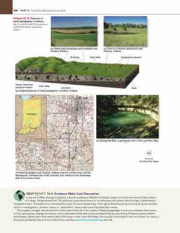
     ▶Figure 14.18 Features of karst topography in indiana. [(b), (c), and (e) Bobbé Christopherson. (d) Mitchell, Indiana quadrangle, USGS.]
Deeply entrenched permanent stream
(b) Rolling karst landscape and cornfields near Orleans, Indiana.
   Karst valley
(a) Idealized features of karst topography in southern Indiana.
°
(d) Karst topography near Orleans, Indiana; note the contour lines and the depressions, indicated with small hachures (tick marks) on the downslope side of the contour lines.
Limestone
Sinkholes
(c) Pond in a sinkhole depression near Palmyra, Indiana.
Disappearing streams
Shale
(e) Orangeville Rise, a spring just north of the Lost River Rise.
Notebook
Karst Farm Park, Indiana
Karst valley
             40°
38°
8
8° 8
6°
Orleans
42
40°
 Indiana
   0 50 100 KILOMETRES
  Georeport 14.4 Amateurs make Cave Discoveries
In the early 1940s, George Colglazier, a farmer southwest of Bedford, Indiana, awoke to find his farm pond at the bottom of a deep, collapsed sinkhole. This sinkhole is now the entrance to an extensive cave system that includes a subterranean
navigable stream. The exploration and scientific study of caves is speleology. Although professional physical and biological scientists carry on investigations, amateur cavers, or “spelunkers,” have made many important discoveries.
The mystery, intrigue, and excitement of cave exploration lie in the variety of dark passageways, enormous chambers that narrow to tiny crawl spaces, strange formations, and underwater worlds that can be accessed only by cave diving. Private-property owners and amateur adventurers discovered many of the major caves, a fact that keeps this popular science/sport very much alive. For nearly a thousand worldwide links and more information, see the www.cbel.com/speleology web site.


