Page 498 - Geosystems An Introduction to Physical Geography 4th Canadian Edition
P. 498
 462 part III The Earth–Atmosphere Interface
   Cable tower (a road bridge may be used)
(a)
Stream bank
Staff gauge
Streambed
Stream surface
Recording instrument and gauge
   Car
Intake pipe
Cable
Suspended current metre
    Cross-section unit of stream
Stilling well
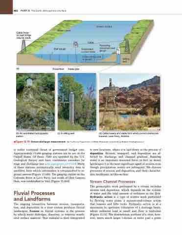
           (b) An automated hydrographic station.
(c) A stilling well.
(d) Cable towers and cable from which current metres are lowered, Lees Ferry, Arizona.
▲Figure 15.10 Stream-discharge measurement. [(b) California Department of Water Resources. (c) and (d) by Bobbé Christopherson.]
is under continual threat of government budget cuts. Approximately 11000 gauging stations are in use in the United States. Of these, 7500 are operated by the U.S. Geological Survey and have continuous recorders for stage and discharge (see pubs.usgs.gov/circ/circ1123/). Many of these stations automatically send telemetry data to satellites, from which information is retransmitted to re- gional centres (Figure 15.10b). The gauging station on the Colorado River at Lee’s Ferry, just south of Glen Canyon Dam, was established in 1921 (Figure 15.10d).
Fluvial Processes and Landforms
The ongoing interaction between erosion, transporta- tion, and deposition in a river system produces fluvial landscapes. Erosion in fluvial systems is the process by which water dislodges, dissolves, or removes weath- ered surface material. This material is then transported
to new locations, where it is laid down in the process of deposition. Erosion, transport, and deposition are af- fected by discharge and channel gradient. Running water is an important erosional force; in fact, in desert landscapes it is the most significant agent of erosion even though precipitation events are infrequent. We discuss processes of erosion and deposition, and their character- istic landforms, in this section.
Stream Channel Processes
The geomorphic work performed by a stream includes erosion and deposition, which depends on the volume of water and the total amount of sediment in the flow. Hydraulic action is a type of erosive work performed by flowing water alone, a squeeze-and-release action that loosens and lifts rocks. Hydraulic action is at a maximum in upstream tributaries of a drainage basin, where sediment load is small and flow is turbulent (Figure 15.11). The downstream portions of a river, how- ever, move much larger volumes of water past a given


