Page 505 - Geosystems An Introduction to Physical Geography 4th Canadian Edition
P. 505
Chapter 15 River Systems 469
   location of the boundary for any legal situation involving the border (see Geosystems Now, Chapter 1).
An interesting case of river boundaries involves the determination of the St. Croix River as the boundary be- tween Maine in the United States and New Brunswick in Canada (Figure GN 1.2). In 1783 with the Treaty of Paris, the boundaries between the United States and what is now Canada were drawn up. It was agreed that the St. Croix River would be the boundary. Disputes arose over whether the channel margins, channel midline, or some other location was the actual boundary. The St. Croix River was the first to have an identification at- tached that was based on the function of the river. The boundary was determined to be the thalweg (zone of maximum depth) of the river.
Recognizing that the thalweg changed over time with erosion and deposition along the riverbank, the commissioners relied on river soundings taken by the United States Coast Guard and the Geodetic Survey to determine the location of the thalweg. So, although the river was used as the boundary, potential disputes were resolved through reference to the stream’s hydrology and morphology.
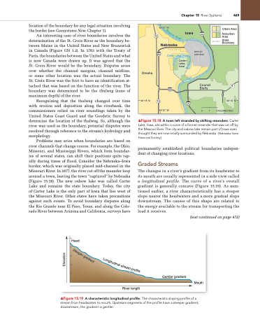
Problems may arise when boundaries are based on river channels that change course. For example, the Ohio, Missouri, and Mississippi Rivers, which form boundar- ies of several states, can shift their positions quite rap- idly during times of flood. Consider the Nebraska–Iowa border, which was originally placed mid-channel in the Missouri River. In 1877, the river cut off the meander loop around a town, leaving the town “captured” by Nebraska (Figure 15.18). The new oxbow lake was called Carter Lake and remains the state boundary. Today, the city of Carter Lake is the only part of Iowa that lies west of the Missouri River. Other states have taken precautions against such events. To avoid boundary disputes along the Rio Grande near El Paso, Texas, and along the Colo- rado River between Arizona and California, surveys have
▲Figure 15.18 A town left stranded by shifting meanders. Carter Lake, Iowa, sits within a curve of a former meander that was cut off by the Missouri River. The city and oxbow lake remain part of Iowa even thought they are now mostly surrounded by nebraska. [nebraska State Historical Society.]
permanently established political boundaries indepen- dent of changing river locations.
Graded Streams
The changes in a river’s gradient from its headwater to its mouth are usually represented in a side view called a longitudinal profile. The curve of a river’s overall gradient is generally concave (Figure 15.19). As men- tioned earlier, a river characteristically has a steeper slope nearer the headwaters and a more gradual slope downstream. The causes of this shape are related to the energy available to the stream for transporting the load it receives.
(text continued on page 472)
      95°57’ W 75
480
Iowa Nebraska
Carter Lake
29
EPPLEY AIRFIELD
Council Bluffs
0 1
 Omaha
40°15’ N
480
Carter Lake, Iowa
29
6
40°15’ N 2 KILOMETRES
 ▲Figure 15.19 A characteristic longitudinal profile. The characteristic sloping profile of a stream from headwaters to mouth. Upstream segments of the profile have a steeper gradient; downstream, the gradient is gentler.
Urban Area
Nonurban Area State Boundary
    75
95°57’ W
    Head
Gentler gradient
Mouth
 River length
Mi
s
so
u
ri
Ri
v
e
r
Steeper gradient
Elevation
L
o
n
g
i
t
u
d
i
n
a
l
s
t
r
e
a
m
p
r
o
f
i
l
e


