Page 504 - Geosystems An Introduction to Physical Geography 4th Canadian Edition
P. 504
 468 part III The Earth–Atmosphere Interface
 The Paraná, and other rivers in South America, exhibit this pattern, as do rivers in Canada, Alaska, and parts of Asia.
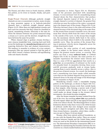
Single-Thread Channels Although perfectly straight channels are rare or nonexistent in nature, many streams in steep mountain regions or in bedrock-controlled channels have a relatively straight channel pattern (Figure 15.17). Often these are high-gradient streams and have such low sinuosity that they cannot be classified as typical, meandering streams. (Sinuosity is the ratio be- tween the distance between two points measured along a stream as it curves and the shortest, straight-line dis- tance between the same two points).
Where channel slope is gradual, streams develop a more sinuous (snakelike) form, weaving back and forth across the landscape in a meandering stream pattern and acquiring distinctive flow and channel characteristics. The tendency to meander is evidence of a river system’s propensity (like any natural system) to find the path of least effort toward a balance between self-equilibrating order and chaotic disorder.
▲Figure 15.17 A straight channel pattern. Relatively straight channel pattern controlled by bedrock on the Ottauquechee River in Quechee gorge, Vermont. [Fraser Hall/ Robert Harding World Imagery/Corbis.]
Geosystems in Action, Figure GIA 15, illustrates some of the processes associated with meandering streams. A cross-sectional view of a meandering stream channel shows the flow characteristics that produce the channel deposits typical of these streams. In a straight channel or section of channel, the greatest flow velocities are near the surface at the centre, correspond- ing to the deepest part of the stream (Figure GIA 15.1a). Velocities decrease closer to the sides and bottom of the channel because of the frictional drag on the water flow. As the stream flows around a meander curve, the maxi- mum flow velocity shifts from the centre of the stream to the outside of the curve. As the stream then straight- ens, the maximum velocity shifts back to the centre, until the next bend, where it shifts to the outside of that meander curve. Thus, the portion of the stream flow- ing at maximum velocity moves diagonally across the stream from bend to bend.
Because the outer portion of each meandering curve is subject to the fastest water velocity, it un- dergoes the greatest erosive action, or scouring. This action can form a steep undercut bank, or cutbank (Figure GIA 15.1b). In contrast, the inner portion of a meander experiences the slowest water velocity and thus is a zone of fill (or aggradation) that results in a point bar, an accumulation of sediment on the inside of a meander bend. As meanders develop, these scour- and-fill processes gradually work at stream banks, causing them to move laterally across a valley—this is the process of lateral erosion. As a result, the landscape near a meandering river bears marks called meander scars that are the residual deposits from previous river channels (seen in the map and image of the Mississippi River’s meanders in Figure 15.24).
Meandering streams create a remarkable looping pattern on the landscape, as shown in Figure GIA 15.2. Actively meandering streams erode their outside banks as they migrate, often forming a narrow neck of land that eventually erodes through and forms a cutoff. A cutoff marks an abrupt change in the stream’s lateral movements—the stream becomes straighter.
After the former meander becomes isolated from the rest of the river, the resulting oxbow lake may gradually fill with organic debris and silt or may again become part of the river when it floods. The Mississippi River is many kilometres shorter today than it was in the 1830s because of artificial cutoffs that were dredged across meander necks to improve navigation and safety. How many of these stream features—meanders, oxbow lakes, cutoffs— can you spot in Figure 15.24 just ahead?
Streams often form natural political boundaries, as we saw with the Danube River earlier. There are several locations between Canada and the United States where rivers are used as the divide for the international bound- ary. The International Boundary Commission (IBC) is re- sponsible for maintaining the boundary between the two countries in a clearly marked fashion and for defining the


