Page 519 - Geosystems An Introduction to Physical Geography 4th Canadian Edition
P. 519
Chapter 15 River Systems 483
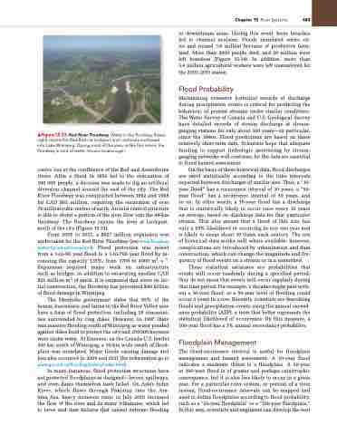
    ▲Figure 15.33 Red River Floodway. Water in the floodway (lower right) rejoins the Red River at Lockport and continues northward into Lake Winnipeg. During most of the year, unlike this scene, the floodway is void of water. [gordon golsborough.]
centre lies at the confluence of the Red and Assiniboine rivers. After a flood in 1950 led to the evacuation of 100 000 people, a decision was made to dig an artificial diversion channel around the east of the city. The Red River Floodway was constructed between 1962 and 1968 for CAD $63 million, requiring the excavation of over 76 million cubic metres of earth. An inlet control structure is able to divert a portion of the river flow into the 48-km floodway. The floodway rejoins the river at Lockport, north of the city (Figure 15.33).
From 2005 to 2011, a $627 million expansion was undertaken for the Red River Floodway (see www.floodway authority.mb.ca/home.html). Flood protection was raised from a 1-in-90 year flood to a 1-in-700 year flood by in- creasing the capacity 135%, from 1700 to 4000 m3 ∙ s−1. Expansion required major work on infrastructure such as bridges, in addition to excavating another CAD $21 million m3 of earth. It is estimated that since its ini- tial construction, the floodway has prevented $40 billion of flood damage in Winnipeg.
The Manitoba government states that 95% of the homes, businesses, and farms in the Red River Valley now have a form of flood protection, including 18 communi- ties surrounded by ring dikes. However, in 1997 there was massive flooding south of Winnipeg as water ponded against dikes built to protect the city and 200000 hectares were under water. At Emerson, on the Canada-U.S. border 100 km south of Winnipeg, a 30-km wide swath of flood- plain was inundated. Major floods causing damage and loss also occurred in 2009 and 2011 (for information go to www.gov.mb.ca/flooding/history/index.html).
In many instances, flood protection structures have not protected floodplains as designed—levees, spillways, and even dams themselves have failed. On Asia’s Indus River, which flows through Pakistan into the Ara- bian Sea, heavy monsoon rains in July 2010 increased the flow of the river and its many tributaries, which led to levee and dam failures that caused extreme flooding
in downstream areas. During this event, levee breaches led to channel avulsion. Floods inundated entire cit- ies and ruined 3.6 million hectares of productive farm- land. More than 2000 people died, and 20 million were left homeless (Figure 15.34). In addition, more than 5.4 million agricultural workers were left unemployed for the 2010–2011 season.
Flood Probability
Maintaining extensive historical records of discharge during precipitation events is critical for predicting the behaviour of present streams under similar conditions. The Water Survey of Canada and U.S. Geological Survey have detailed records of stream discharge at stream- gauging stations for only about 100 years—in particular, since the 1940s. Flood predictions are based on these relatively short-term data. Scientists hope that adequate funding to support hydrologic monitoring by stream- gauging networks will continue, for the data are essential to flood hazard assessment.
On the basis of these historical data, flood discharges are rated statistically according to the time intervals expected between discharges of similar size. Thus, a “10- year flood” has a recurrence interval of 10 years, a “50- year flood” has a recurrence interval of 50 years, and so on. In other words, a 10-year flood has a discharge that is statistically likely to occur once every 10 years on average, based on discharge data for that particular stream. This also means that a flood of this size has only a 10% likelihood of occurring in any one year and is likely to occur about 10 times each century. The use of historical data works well where available; however, complications are introduced by urbanization and dam construction, which can change the magnitude and fre- quency of flood events on a stream or in a watershed.
These statistical estimates are probabilities that events will occur randomly during a specified period; they do not mean that events will occur regularly during that time period. For example, 2 decades might pass with- out a 50-year flood; or a 50-year level of flooding could occur 3 years in a row. Recently, scientists are describing floods and precipitation events using the annual exceed- ance probability (AEP), a term that better represents the statistical likelihood of occurrence. By this measure, a 100-year flood has a 1% annual exceedance probability.
Floodplain Management
The flood-recurrence interval is useful for floodplain management and hazard assessment. A 10-year flood indicates a moderate threat to a floodplain. A 50-year or 100-year flood is of greater and perhaps catastrophic consequence, but it is also less likely to occur in a given year. For a particular river system, or portion of a river system, flood-recurrence intervals can be mapped and used to define floodplains according to flood probability, such as a “50-year floodplain” or a “100-year floodplain.” In this way, scientists and engineers can develop the best


