Page 518 - Geosystems An Introduction to Physical Geography 4th Canadian Edition
P. 518
 482 part III The Earth–Atmosphere Interface
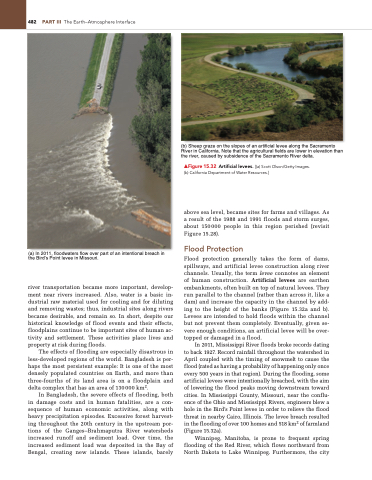
     (a) In 2011, floodwaters flow over part of an intentional breach in the Bird’s Point levee in Missouri.
river transportation became more important, develop- ment near rivers increased. Also, water is a basic in- dustrial raw material used for cooling and for diluting and removing wastes; thus, industrial sites along rivers became desirable, and remain so. In short, despite our historical knowledge of flood events and their effects, floodplains continue to be important sites of human ac- tivity and settlement. These activities place lives and property at risk during floods.
The effects of flooding are especially disastrous in less-developed regions of the world. Bangladesh is per- haps the most persistent example: It is one of the most densely populated countries on Earth, and more than three-fourths of its land area is on a floodplain and delta complex that has an area of 130000 km2.
In Bangladesh, the severe effects of flooding, both in damage costs and in human fatalities, are a con- sequence of human economic activities, along with heavy precipitation episodes. Excessive forest harvest- ing throughout the 20th century in the upstream por- tions of the Ganges–Brahmaputra River watersheds increased runoff and sediment load. Over time, the increased sediment load was deposited in the Bay of Bengal, creating new islands. These islands, barely
(b) Sheep graze on the slopes of an artificial levee along the Sacramento River in California. Note that the agricultural fields are lower in elevation than the river, caused by subsidence of the Sacramento River delta.
▲Figure 15.32 Artificial levees. [(a) Scott Olson/getty Images. (b) California Department of Water Resources.]
above sea level, became sites for farms and villages. As a result of the 1988 and 1991 floods and storm surges, about 150000 people in this region perished (revisit Figure 15.28).
Flood Protection
Flood protection generally takes the form of dams, spillways, and artificial levee construction along river channels. Usually, the term levee connotes an element of human construction. Artificial levees are earthen embankments, often built on top of natural levees. They run parallel to the channel (rather than across it, like a dam) and increase the capacity in the channel by add- ing to the height of the banks (Figure 15.32a and b). Levees are intended to hold floods within the channel but not prevent them completely. Eventually, given se- vere enough conditions, an artificial levee will be over- topped or damaged in a flood.
In 2011, Mississippi River floods broke records dating to back 1927. Record rainfall throughout the watershed in April coupled with the timing of snowmelt to cause the flood (rated as having a probability of happening only once every 500 years in that region). During the flooding, some artificial levees were intentionally breached, with the aim of lowering the flood peaks moving downstream toward cities. In Mississippi County, Missouri, near the conflu- ence of the Ohio and Mississippi Rivers, engineers blew a hole in the Bird’s Point levee in order to relieve the flood threat in nearby Cairo, Illinois. The levee breach resulted in the flooding of over 100 homes and 518 km2 of farmland (Figure 15.32a).
Winnipeg, Manitoba, is prone to frequent spring flooding of the Red River, which flows northward from North Dakota to Lake Winnipeg. Furthermore, the city


