Page 525 - Geosystems An Introduction to Physical Geography 4th Canadian Edition
P. 525
  Chapter 15 River Systems 489
  Looking for additional review and test prep materials? Visit the Study Area in MasteringGeographyTM to enhance your geographic literacy, spatial reasoning skills, and understanding of this chapter’s content by accessing a variety of resources, including interactive maps, geoscience animations, satellite loops, author notebooks, videos, RSS feeds, web links, self-study quizzes, and an eText version of Geosystems.
       visualanalysis 15 Horton River and Its Delta
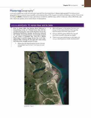
 Prior to about 1800, the Horton River followed a meandering course as it flowed more then 100 km northward along the coast of the Beaufort Sea in the Northwest Territories, Canada. As the river scoured the outside of meander bends, it eventually formed a new outlet to Franklin Bay. This EO–1 (Earth Observing–1) satellite image shows the river’s fan- shaped delta, forming for the past 200 years along this otherwise straight section of coast.
1. Where the river abandoned its former channel, oxbow lakes have formed. How many can you count?
2. What will happen in this system if erosion con- tinues on the undercut bank of the meander bend located in the lower right corner?
3. Can you identify a place where the river will soon form a cutoff to shorten its length?
4. There is one main distributary on the delta, but can you identify several smaller distributaries?
  [nASA EO–1 Team.]


