Page 527 - Geosystems An Introduction to Physical Geography 4th Canadian Edition
P. 527
 now
geosystems
 Coastal Communities Facing Changes
Coastlines are dynamic environments at the interface between land and bodies of water, constantly changing as energy associated with the movement of water is absorbed and redistributed. This chapter shows how the absorption of energy contained in wave, tide, and cur- rent motions explains coastal processes and the creation of coastal landforms. We created many present-day problems by building communities at coastlines with- out fully recognizing the effect this could have on the dynamic coastal environment. in many places we are now forced to deal with resulting coastal hazards and imple- ment adaptive strategies to accommo- date coastal changes.
While sea level rise is not always the cause of coastal erosion or flooding, ris- ing sea level linked to global climate change and melting glaciers is increas- ing the severity and frequency of these processes. The hamlet of Tuktoyaktuk, northwest Territories, on the Beaufort Sea coast is experiencing the effects of sea level rise (3–4 mm per year) but those effects are further compounded by two related impacts of warming climate: melt- ing permafrost, which destabilizes the ground, and reduced sea ice in the arctic Ocean, which eliminates an important buffer against wave energy.
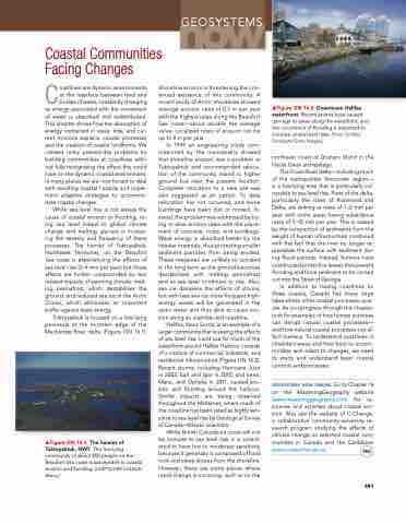
Tuktoyaktuk is located on a low-lying peninsula at the northern edge of the Mackenzie river delta (Figure gn 16.1).
Shoreline erosion is threatening the con- tinued existence of this community. a recent study of arctic shorelines showed average erosion rates of 0.5 m per year with the highest rates along the Beaufort Sea coast—about double the average value. Localized rates of erosion can be up to 8 m per year.
in 1994 an engineering study com- missioned by the municipality showed that shoreline erosion was a problem at Tuktoyaktuk and recommended reloca- tion of the community inland to higher ground but near the present location. Complete relocation to a new site was also suggested as an option. To date relocation has not occurred, and some buildings have been lost or moved. in- stead, the problem was addressed by try- ing to slow erosion rates with the place- ment of concrete, rocks, and sandbags. Wave energy is absorbed better by the heavier materials, thus protecting smaller sediment particles from being eroded. These measures are unlikely to succeed in the long term as the ground becomes destabilized with melting permafrost and as sea level continues to rise. also, sea ice dampens the effects of storms, but with less sea ice more frequent high- energy waves will be generated in the open water and thus able to cause ero- sion along an unprotected coastline.
Halifax, nova Scotia, is an example of a larger community that is seeing the effects of sea level rise. Land use for much of the waterfront around Halifax Harbour consists of a mixture of commercial, industrial, and residential infrastructure (Figure gn 16.2). recent storms, including Hurricane Juan in 2003, earl and igor in 2010, and irene, Maria, and Ophelia in 2011, caused ero- sion and flooding around the harbour. Similar impacts are being observed throughout the Maritimes, where much of the coastline has been rated as highly sen- sitive to sea level rise by geological Survey of Canada–atlantic scientists.
While British Columbia’s coast will not be immune to sea level rise, it is consid- ered to have low to moderate sensitivity because it generally is composed of hard rock and steep slopes from the shoreline. However, there are some places where rapid change is occurring, such as on the
▲Figure GN 16.2 Downtown Halifax waterfront. recent storms have caused damage to areas along the waterfront, and the occurrence of flooding is expected to increase as sea level rises. [Peter gridley/ Stockbyte/getty images.]
northeast coast of graham island in the Haida gwaii archipelago.
The Fraser river delta—including much of the metropolitan Vancouver region— is a low-lying area that is particularly vul- nerable to sea level rise. Parts of the delta, particularly the cities of richmond and Delta, are sinking at rates of 1–2 mm per year, with some areas having subsidence rates of 5–10 mm per year. This is caused by the compaction of sediments from the weight of human infrastructure combined with the fact that the river no longer re- plenishes the surface with sediment dur- ing flood periods. instead, humans have constructed protective levees that prevent flooding and force sediment to be carried out into the Strait of georgia.
in addition to having coastlines on three oceans, Canada has many large lakes where other coastal processes oper- ate. as you progress through this chapter, look for examples of how human activities can disrupt natural coastal processes— and how natural coastal processes can af- fect humans. To understand coastlines in inhabited areas and how best to accom- modate and adapt to changes, we need to study and understand basic coastal controls and processes.
geosystems now online go to Chapter 16 on the MasteringGeography website (www.masteringgeography.com) for re- sources and activities about coastal ero- sion. also see the website of C-Change, a collaborative community-university re- search program studying the effects of climate change on selected coastal com- munities in Canada and the Caribbean www.coastalchange.ca.
   ▲Figure GN 16.1 The hamlet of Tuktoyaktuk, NWT. This low-lying community of about 850 people on the Beaufort Sea coast is susceptible to coastal erosion and flooding. [LOeTSCHer CHLaUS/ alamy.]
 491


