Page 534 - Geosystems An Introduction to Physical Geography 4th Canadian Edition
P. 534
 498 part III The earth–atmosphere interface
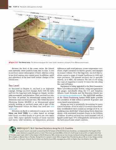
                   ▲Figure 16.5 The littoral zone. The littoral zone spans the coast, beach, nearshore, and part of the offshore environment.
Because the level of the ocean varies, the littoral zone naturally shifts position from time to time. A rise in sea level causes submergence of land, whereas a drop in sea level exposes new coastal areas. In addition, uplift and subsidence of the land itself initiate changes in the littoral zone.
Sea Level
As discussed in Chapter 11, sea level is an important concept. Average sea level changes daily with the tides and over the long term with changes in climate, tectonic plate movements, and glaciation. Thus, sea level is a rela- tive term. At present, no international system exists to determine exact sea level over time. The Global Sea Level Observing System (GLOSS) is an international group actively working on sea-level issues and is part of the larger Permanent Service for Mean Sea Level (see www .psmsl.org/).
Elevation on Earth is referenced to mean sea level. Mean sea level (MSL) is a value based on average tidal levels recorded hourly at a given site over many years. MSL varies spatially because of ocean currents and waves, tidal variations, air temperature, pressure
differences and wind patterns, ocean temperature vari- ations, slight variations in Earth’s gravity, and changes in oceanic volume. Over the long term, sea-level fluctu- ations expose a range of coastal landforms to tidal and wave processes. The present sea-level rise is spatially uneven, as is MSL; for instance, the rate of rise along the coast of Argentina is nearly 10 times the rate along the coast of France.
Equipment is being upgraded in the Next Generation Water Level Measurement System, using next-generation tide gauges, specifically along the U.S. and Canadian Atlantic Coast, Bermuda, and the Hawaiian Islands (see co-ops.nos.noaa.gov/levelhow.html). The NAVSTAR satellites of the Global Positioning System (GPS) make possible the correlation of data within a network of ground- and ocean-based measurements.
Rising sea level is potentially devastating for many coastal locations. A rise of only 0.3 m would cause shore- lines worldwide to move inland an average of 30 m, in- undating some 20000 km2 of land along North American shores, with associated economic losses in the trillions of dollars. A 0.95-m sea-level rise could inundate 15% of Egypt’s arable land, 17% of Bangladesh, and nearly all of the land area of some island countries.
 Georeport 16.2 Sea-level Variations along the U.S. Coastline
at a given instant, sea level varies along the full extent of north american shorelines, as measured by the height of the water relative to a specific point on land. The mean sea level (MSL) of the U.S. gulf Coast is about 25 cm higher than that
of Florida’s east coast, which is the lowest in north america. MSL values rise as one moves northward along the eastern coast, being 38 cm higher in Maine than in Florida. along the U.S. western coast, MSL is higher than Florida’s by about 58 cm in San Diego and by about 86 cm in Oregon. Overall, north america’s Pacific Coast MSL averages about 66 cm higher than the atlantic Coast MSL.
    Coast
Coastal area
Beach (shore)
Nearshore Shoreline
Offshore
Cliffs
Back shore
Foreshore
Surf zone
Breakers Terrace
High tide Low tide
Littoral zone
Bar
About 60 m


