Page 533 - Geosystems An Introduction to Physical Geography 4th Canadian Edition
P. 533
 MISSISSIPPI
ALABAMA
Mobile
GEORGIA
60°
Site of 1989 Exxon Valdez oil-spill
80° 160° 140° 120° 100° 80° 60° 40° 20° 0° 20° 40° 60° 80° 100° 120° 140° 160° 80°
ATLANTIC
Tropic of Capricorn
Antarctic Circle
60°
20°
0°
PACIFIC OCEAN
20°
0°
40° disaster Tropic of Cancer
PACIFIC
OCEAN
40°
ATLANTIC OCEAN
Chapter 16 Oceans, Coastal Systems, and Wind Processes
497
OCEAN
INDIAN OCEAN
Equator
CORAL SEA
25°N
30°N
LOUISIANA
New Orleans
Biloxi
3000 KILOMETRES
Extent of oil spill
Deepwater Horizon
oil drilling platform
0 150 300 KILOMETRES
90°W
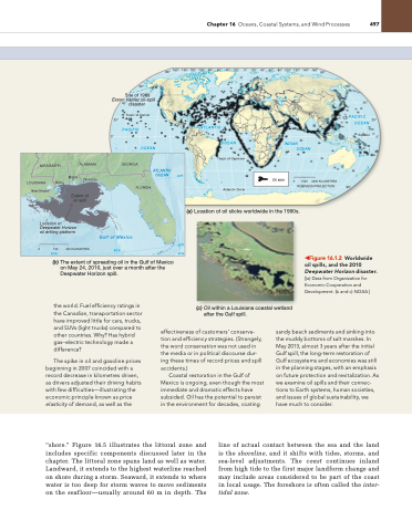
(a) Location of oil slicks worldwide in the 1990s.
(c) Oil within a Louisiana coastal wetland after the Gulf spill.
Location of
Pensacola
Oil slick
0 1500
ROBINSON PROJECTION
Gulf of Mexico
85°W
80°W
(b) The extent of spreading oil in the Gulf of Mexico on May 24, 2010, just over a month after the Deepwater Horizon spill.
◀Figure 16.1.2 Worldwide oil spills, and the 2010 Deepwater Horizon disaster. [(a) Data from Organization for economic Cooperation and Development. (b and c) nOaa.]
the world. Fuel efficiency ratings in the Canadian, transportation sector have improved little for cars, trucks, and SUVs (light trucks) compared to other countries. Why? Has hybrid gas–electric technology made a difference?
The spike in oil and gasoline prices beginning in 2007 coincided with a record decrease in kilometres driven, as drivers adjusted their driving habits with few difficulties—illustrating the economic principle known as price elasticity of demand, as well as the
effectiveness of customers’ conserva- tion and efficiency strategies. (Strangely, the word conservation was not used in the media or in political discourse dur- ing these times of record prices and spill accidents.)
Coastal restoration in the gulf of Mexico is ongoing, even though the most immediate and dramatic effects have subsided. Oil has the potential to persist in the environment for decades, coating
sandy beach sediments and sinking into the muddy bottoms of salt marshes. in May 2013, almost 3 years after the initial gulf spill, the long-term restoration of gulf ecosystems and economies was still in the planning stages, with an emphasis on future protection and revitalization. as we examine oil spills and their connec- tions to earth systems, human societies, and issues of global sustainability, we have much to consider.
“shore.” Figure 16.5 illustrates the littoral zone and includes specific components discussed later in the chapter. The littoral zone spans land as well as water. Landward, it extends to the highest waterline reached on shore during a storm. Seaward, it extends to where water is too deep for storm waves to move sediments on the seafloor—usually around 60 m in depth. The
line of actual contact between the sea and the land is the shoreline, and it shifts with tides, storms, and sea-level adjustments. The coast continues inland from high tide to the first major landform change and may include areas considered to be part of the coast in local usage. The foreshore is often called the inter- tidal zone.
FLORIDA
60°


