Page 531 - Geosystems An Introduction to Physical Geography 4th Canadian Edition
P. 531
Chapter 16 Oceans, Coastal Systems, and Wind Processes 495
  Greenland Latitude
South Atlantic 60° S
Approximate conditions at 30° latitude
0 20° C 0
11 22 33 4
0° C
60° N
30° N 0°
30° S
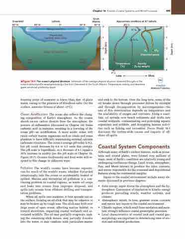
               Mixing zone (2%)
Thermocline transition zone (18%)
Deep cold zone (80%)
freezing point of seawater is lower than that of plain water, owing to the presence of dissolved salts. (At the surface, seawater freezes at about –2°C.)
Ocean Acidification The ocean also reflects the chang- ing composition of Earth’s atmosphere. As the oceans absorb excess carbon dioxide from the atmosphere, the process of carbonation (discussed in Chapter 14) forms carbonic acid in seawater, resulting in a lowering of the ocean pH—an acidification. A more acidic ocean will cause certain marine organisms such as corals and some plankton to have difficulty maintaining external calcium carbonate structures. The ocean’s average pH today is 8.2, but pH could decrease by 0.4 to 0.5 units this century. The pH scale is logarithmic, so a decrease of 0.1 equals a 30% increase in acidity (see the pH scale in Chapter 18, Figure 18.7). Oceanic biodiversity and food webs will re- spond to this change in unknown ways.
Pollution The world’s oceans have become reposito- ries for much of the world’s waste, whether discarded intentionally into the ocean or accidentally leaked or spilled. Marine and terrestrial oil pollution is a con- tinuing problem in coastal regions, as waste oil seeps and leaks into oceans from improper disposal, and spills into oceans from offshore drilling and transpor- tation problems.
When oil spills into seawater, it first spreads out on the surface, forming an oil slick that may be cohesive or may be broken up by rough seas. The slick may drift over large areas of open ocean, affecting marine habitat, or toward shorelines, impacting coastal wetlands and as- sociated wildlife. The oil may partially evaporate, mak- ing the remaining slick denser, may partially dissolve into the water, or may combine with particulate matter
and sink to the bottom. Over the long term, some of the oil breaks down through processes driven by sunlight and through decomposition by microorganisms—the rate of this deterioration depends on temperature and the availability of oxygen and nutrients. Along a coast- line, oil spreads over beach sediments and drifts into coastal wetlands, contaminating and poisoning aquatic organisms and wildlife, and disrupting human activi- ties such as fishing and recreation. Focus Study 16.1 discusses the system-wide causes and impacts of off- shore oil spills.
Coastal System Components
Although many of Earth’s surface features, such as moun- tains and crustal plates, were formed over millions of years, most of Earth’s coastlines are relatively young and undergoing continuous change. Land, ocean, atmosphere, Sun, and Moon interact to produce the tides, currents, and waves responsible for the erosional and depositional features along the continental margins.
Inputs to the coastal environment include many ele- ments discussed in previous chapters:
• Solar energy input drives the atmosphere and the hy- drosphere. Conversion of insolation to kinetic energy produces prevailing winds, weather systems, and climate.
• Atmospheric winds, in turn, generate ocean currents and waves, key inputs to the coastal environment.
• Climatic regimes, which result from insolation and mois- ture, strongly influence coastal geomorphic processes.
• Local characteristics of coastal rock and coastal geo-
morphology are important in determining rates of ero- sion and sediment production.
37 ‰ 34 ‰
      Ocean floor
Ocean floor
Less More
02 C02 Dissolved gases
   Temperature (°C)
Salinity (‰ by weight)
4
Animation
Midlatitude Productivity
 ▲Figure 16.4 The ocean’s physical structure. Schematic of the average physical structure observed throughout the ocean’s vertical profile as sampled along a line from greenland to the South atlantic. Temperature, salinity, and dissolved gases are shown plotted by depth.
Depth (km)
Depth (km)


