Page 542 - Geosystems An Introduction to Physical Geography 4th Canadian Edition
P. 542
 506 part III The earth–atmosphere interface
 F cus Study 16.2 Natural Hazards The 2011 Japan Tsunami
    On March 11, 2011, just minutes after the Tohoku earthquake hit Japan, its epicen- tre about 129 km offshore of the island of Honshu (discussed in Chapter 13, Focus Study 13.2), tsunami warnings went out across the country. eight to 10 minutes after the quake, the first tsunami wave hit the northeastern coast of Honshu,
the closest shoreline to the earthquake’s epicentre.
Tsunami wave heights averaged 10 m in some areas and reached
30 m in narrow harbours. at Ofunato,
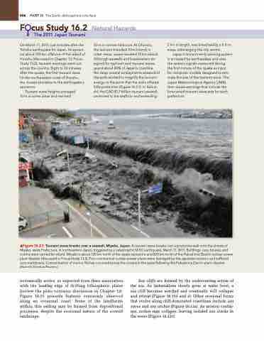
the tsunami travelled 3 km inland; in other areas, waves reached 10 km inland. although seawalls and breakwaters de- signed for typhoon and tsunami waves guard about 40% of Japan’s coastline, the deep coastal embayments seaward of the walls worked to magnify the tsunami energy to the point that the walls offered little protection (Figure 16.2.1). in Kamai- shi, the CaD $1.7 billion tsunami seawall, anchored to the seafloor and extending
2 km in length, was breached by a 6.8-m wave, submerging the city centre.
Japan’s tsunami early warning system is activated by earthquakes and uses
the seismic signals measured during
the first minute of the quake as input
for computer models designed to esti- mate the size of the tsunami wave. The Japan Meteorological agency (JMa) then issues warnings that include the forecasted tsunami wave size for each prefecture.
 ▲Figure 16.2.1 Tsunami wave breaks over a seawall, Miyako, Japan. a tsunami wave breaks over a protective wall onto the streets of Miyako, iwate Prefecture, in northeastern Japan, triggered by a catastrophic M 9.0 earthquake, March 11, 2011. Buildings, cars, houses, and victims were carried far inland. Miyako is about 120 km north of the quake epicentre and 200 km north of the Fukushima Daiichi nuclear power plant disaster (discussed in Focus Study 13.2). Four commercial nuclear power plants were damaged by the Japanese tsunami and suffered core meltdowns. Contamination of marine life has occurred across the oceans in the years following the Fukushima Daiichi plant disaster. [Mainichi Shimbun/reuters.]
tectonically active, as expected from their association with the leading edge of drifting lithospheric plates (review the plate tectonics discussion in Chapter 12). Figure 16.13 presents features commonly observed along an erosional coast. Some of the landforms within this setting may be formed from depositional processes, despite the erosional nature of the overall landscape.
Sea cliffs are formed by the undercutting action of the sea. As indentations slowly grow at water level, a sea cliff becomes notched and eventually will collapse and retreat (Figure 16.13d and e). Other erosional forms that evolve along cliff-dominated coastlines include sea caves and sea arches (Figure 16.13a). As erosion contin- ues, arches may collapse, leaving isolated sea stacks in the water (Figure 16.13c).


