Page 547 - Geosystems An Introduction to Physical Geography 4th Canadian Edition
P. 547
Chapter 16 Oceans, Coastal Systems, and Wind Processes 511
   In contrast to “hard” protection, the hauling of sand to replenish a beach is considered “soft” shoreline protec- tion. Beach nourishment refers to the artificial replace- ment of sand along a beach. Theoretically, through such efforts, a beach that normally experiences a net loss of sed- iment will be fortified with new sand. However, years of human effort and expense to build beaches can be erased by a single storm. In addition, disruption of marine and lit- toral zone ecosystems may occur if the new sand does not physically and chemically match the existing sand.
In Florida, local, state, and federal agencies spend over USD $100 million annually on replenishment proj- ects and manage over 300 kilometres of restored beaches. Until recently, sand was pumped from offshore onto the beach. However, over 30 years of dredging for sand has depleted offshore sand supplies, and now sand trans- port from far-away source areas is necessary. In Virginia Beach, Virginia, a USD $9 million beach replenishment project in 2013 rebuilt a strip of sand for the 49th time since 1951. The Army Corps of Engineers, which typi- cally executes such projects on the U.S. East Coast, states that beach replenishment saves money in the long run by preventing damage to coastal development. Others, in- cluding scientists and politicians, disagree. At present, the federal government pays for about 65% of all beach replenishment projects, with the remaining cost picked up by state and local communities.
Barrier Beaches and Islands
Barrier beaches are long, narrow depositional features, generally of sand, that form offshore roughly parallel to the coast. When these features are broader and more extensive, they are called barrier islands. The sediment supplied to these beaches often comes from alluvial coastal plains, and tidal variation near these features usually is moder- ate to low. Barrier beaches and islands are quite common worldwide, lying offshore of nearly 10% of Earth’s coast- lines. Examples are found off Africa, India’s eastern coast, Sri Lanka, Australia, and Alaska’s northern slope, as well as offshore in the Baltic and Mediterranean Seas. Earth’s most extensive chain of barrier islands is along the U.S. Atlantic and Gulf Coasts, extending some 5000 km from Long Island to Texas and Mexico.
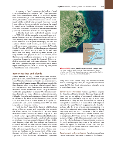
North Carolina’s famed Outer Banks is a 320-km long string of barrier islands and peninsulas that separate the Atlantic Ocean from the mainland. The Outer Banks stretch southward from Virginia Beach, Virginia, to Cape Lookout, and are separated from the mainland by Pamlico Sound (sound is a general term for a body of water forming an inlet) and two other sounds to the north (Figure 16.16). Mud flats (also called tidal flats) and salt marshes (a type of coastal wetland) are characteristic low-relief environ- ments on the landward side of a barrier formation, where tidal influence is greater than wave action. Typical land- forms are foredunes on the seaward side of the forma- tion and backdunes and lagoons on the landward side. Figure 16.17 shows landforms and associated vegetation
▲Figure 16.16 Barrier island chain along North Carolina coast. The Outer Banks of north Carolina. The area presently is desig- nated as one of 10 national seashore reserves supervised by the U.S. national Park Service. [Terra MODiS, naSa/gSFC.]
along with basic human usage and recommendations from a planning perspective, for a typical barrier island along the U.S. East Coast, although these principles apply to barrier islands everywhere.
Barrier Island Processes Various hypotheses explain the formation of barrier islands. They may begin as off- shore bars or low ridges of submerged sediment near shore and then gradually migrate toward shore with wave action or rising sea level. Barrier beaches naturally shift position in response to wave action and longshore currents. The name “barrier” is appropriate, for these for- mations take the brunt of storm energy, migrating over time with erosion and redeposition. For example, during Hurricane Sandy in 2012, Fire Island, a barrier island and popular summer destination off the southern coast of Long Island, New York, moved 19 to 25 m toward the mainland (Figure 16.18). The processes at work were typi- cal of the effects of storms on barrier islands: erosion on the beach and foredune, deposition in the backdune area and in the lagoon, the formation of new inlets, and gen- eral shifting of the barrier formation toward shore in re- sponse to waves and storm surge.
Development on Barrier Islands Canada does not have coastal barrier islands suitable for extensive development,
      Virginia Beach
0 25 50 KILOMETRES
Kitty Hawk
Nags Head
   ATLANTIC OCEAN
Cape Hatteras Ocracoke Island
 Morehead City
77° Cape Lookout 75°
35°
36°
d
n
u
o
S
o
c
i s
l
m
a
P
k
n
a
B
e
r
o
C


