Page 548 - Geosystems An Introduction to Physical Geography 4th Canadian Edition
P. 548
 512 part III The earth–atmosphere interface
Subject to pollution controls
Tolerant of recreation
Ocean
Intolerant of construction
Tolerant of recreation
Beach
Fragile, easily disturbed
Intolerant of construction and recreation
Foredunes
Plants stabilize sand surfaces
Tolerant of limited construction and recreation
Trough
Intolerant of construction and recreation on seaward-facing side of dunes
Tolerant of construction and recreation on inland-facing side of dunes
Backdunes
Filling not allowed
Intolerant of
construction and recreation
Mud flats and wetlands
Subject to recreation
Tolerant
Lagoon
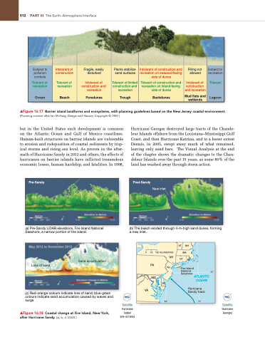
▲Figure 16.17 Barrier island landforms and ecosystems, with planning guidelines based on the New Jersey coastal environment. [Planning content after ian McHarg, Design with Nature, Copyright © 1969.]
but in the United States such development is common on the Atlantic Ocean and Gulf of Mexico coastlines. Human-built structures on barrier islands are vulnerable to erosion and redeposition of coastal sediments by trop- ical storms and rising sea level. As proven in the after- math of Hurricane Sandy in 2012 and others, the effects of hurricanes on barrier islands have inflicted tremendous economic losses, human hardship, and fatalities. In 1998,
Pre-Sandy
(a) Pre-Sandy LiDAR elevations, Fire Island National Seashore, a narrow portion of the island.
Sand accumulation
Loss of sand
(c) Red-orange colours indicate loss of sand; blue-green colours indicate sand accumulation caused by waves and surge.
▲Figure 16.18 Coastal change at Fire island, New York, after Hurricane Sandy. [(a, b, c) USgS.]
Hurricane Georges destroyed large tracts of the Chande- leur Islands offshore from the Louisiana–Mississippi Gulf Coast, and then Hurricane Katrina, and to a lesser extent Dennis, in 2005, swept away much of what remained, leaving only sand bars. The Visual Analysis at the end of the chapter shows the dramatic changes to the Chan- deleur Islands over the past 15 years, as some 80% of the land has washed away through storm action.
Satellite
Hurricane Isabel 9/6–9/19/04
Satellite
Hurricane Georges
Post-Sandy
(b) The beach eroded through 4-m-high sand dunes, forming a new inlet.
0
VA
75 150 KILOMETRES
VT NH MA
PA
New inlet
MD
DE
Seashore ATLANTIC OCEAN
65°
Hurricane Sandy track
70°
NY
RI
NJ
CT
Fire Island National
40°


