Page 561 - Geosystems An Introduction to Physical Geography 4th Canadian Edition
P. 561
 60° 50° 40° 30°
160° 10°
Loess Hills
110° 100° Equator
60° 50°
ATLANTIC 40° OCEAN
30° Tropic of Cancer
20° 10°
50° 40° 30°
50° PACIFIC 40°
OCEAN
Loess Plateau 30° Tropic of Cancer
20°
10° 140° 150°
150° 160° 170° CORAL SEA 20°
30°
0° 140° 130°
10° 20° 30° 40° 50°
120°
90°
0°
10° 20° 30° 40° 50°
60°
80°
ARCTIC OCEAN
ARCTIC OCEAN
70°
Palouse region
20°
PACIFIC OCEAN
Arctic Circle
50°
0
1000
2000
3000 KILOMETRES
40°
40°
110° 120° 130° 140° 150° 160° 180°
MODIFIED GOODE’S HOMOLOSINE EQUAL-AREA PROJECTION
20° 30°
20° 30°
40° 50°
20° 30° 40° 50°
Tropic of Capricorn 30°
40° 50°
10° 10°
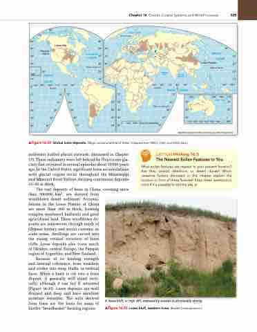
▲Figure 16.34 Global loess deposits. Major accumulations of loess. [adapted from nrCS, FaO, and USgS data.]
meltwater (called glacial outwash, discussed in Chapter 17). These sediments were left behind by Pleistocene gla- ciers that retreated in several episodes about 15000 years ago. In the United States, significant loess accumulations with glacial origins occur throughout the Mississippi and Missouri River Valleys, forming continuous deposits 15–30 m thick.
The vast deposits of loess in China, covering more than 300 000 km2, are derived from
windblown desert sediment. Accumu-
lations in the Loess Plateau of China
CriTiCAlthinking 16.3
The Nearest Eolian Features to You
What eolian features are nearest to your present location? are they coastal, lakeshore, or desert dunes? Which causative factors discussed in this chapter explain the location or form of these features? Keep these questions in mind if it is possible to visit the site. •
are more than 300 m thick, forming complex weathered badlands and good agricultural land. These windblown de- posits are interwoven through much of Chinese history and social customs; in some areas, dwellings are carved into the strong vertical structure of loess cliffs. Loess deposits also cover much of Ukraine, central Europe, the Pampas region of Argentina, and New Zealand.
Because of its binding strength and internal coherence, loess weathers and erodes into steep bluffs, or vertical faces. When a bank is cut into a loess deposit, it generally will stand verti- cally, although it can fail if saturated (Figure 16.35). Loess deposits are well drained and deep and have excellent moisture retention. The soils derived from loess are the basis for some of Earth’s “breadbasket” farming regions.
A loess bluff, or high cliff, exposed by erosion is structurally strong.
▲Figure 16.35 loess bluff, western iowa. [Bobbé Christopherson.]
Chapter 16 Oceans, Coastal Systems, and Wind Processes 525
50° Equator
70°
INDIAN
10° 20°
ARABIAN SEA
BAY OF BENGAL
80° 90°
OCEAN
120° 20°
30°


