Page 585 - Geosystems An Introduction to Physical Geography 4th Canadian Edition
P. 585
Chapter 17 glacial and Periglacial Landscapes 549
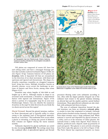
       (a) Topographic map near Peterborough, Ontario, featuring numerous drumlins indicated by the elongated oval patterns of brown contour lines.
Till plains are composed of coarse till, have low and rolling relief, and have a deranged drainage pat- tern that includes scattered wetlands (Figure 17.16b; see also Figure 15.5g). Common features of till plains are drumlins, hills of deposited till that are streamlined in the direction of ice sheet movement, with blunt end upstream and tapered end downstream. The shape of a drumlin sometimes resembles an elongated teaspoon bowl, lying face down. Multiple drumlins, known as drumlin swarms, occur across the landscape in por- tions of Ontario and Nova Scotia, among other areas (Figure 17.17).
Drumlins may attain lengths of 100–5000 m and heights up to 200 m. Although similar in shape to an erosional roche moutonnée, a drumlin is a depositional feature with tapered end downstream. Figure 17.17a shows a portion of a topographic map for an area near Peterborough, Ontario. Can you identify the numerous drumlins on the map? In what direction do you think the ice sheets moved across this region?
Glacial Outwash Beyond the glacial terminus, meltwa- ter flows downstream and is typically milky in colour owing to the sediment load of fine-grained materials, known as “rock flour.” This meltwater flow occurs when a glacier is retreating, or during any period of ablation; flow volumes are highest during the warm summer months.
Sediments deposited by glacial meltwater are sorted by size, becoming stratified drift. The sorting comes from the combined effect of glaciofluvial (glacial and fluvial)
◀Figure 17.17 Drumlins. [From Ontario Ortho Photos, natural resources Canada. Used by per- mission of the Minister of Public Works and government Services.]
(b) Aerial photo of part of the Peterborough drumlin field swarm; differences in vegetation cover makes the drumlins easier to spot.
processes—flowing water sorts sediments according to size, often with the largest particles dropped out of the sediment load closest to the glacial terminus (forming an alluvial fan) and the smaller particles carried farthest downstream. These glaciofluvial sediments are also strati- fied, with sediments laid down in layers.
The area of sediment deposition beyond the gla- cial terminus can form an extensive outwash plain, or sandur (a term that originated in Iceland). Outwash plains feature braided stream channels, which typically form when streams carry a large sediment load. When material is moved and deposited by glacial streams in a valley, such as at the terminus of valley glaciers, the outwash forms a valley train deposit. Peyto Glacier in Alberta, produced such a deposit, made up primarily of sand and gravel. This glacier is now actively retreating from Peyto Lake (the glacier is far left in Figure 17.18). The Peyto Glacier has experienced massive ice losses


