Page 586 - Geosystems An Introduction to Physical Geography 4th Canadian Edition
P. 586
 550 part III The earth–atmosphere interface
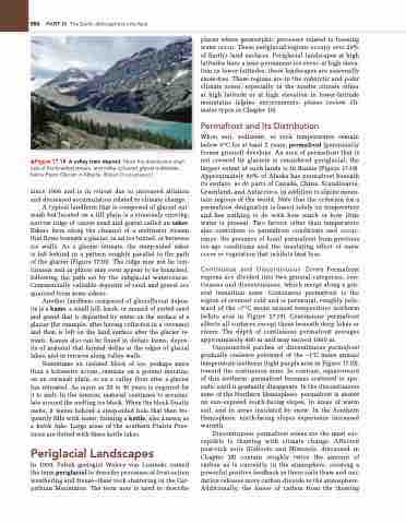
   ▲Figure 17.18 A valley train deposit. note the distributary chan- nels of the braided stream, and milky-coloured glacial meltwater, below Peyto glacier in alberta. [robert Christopherson.]
since 1966 and is in retreat due to increased ablation and decreased accumulation related to climate change.
A typical landform that is composed of glacial out- wash but located on a till plain is a sinuously curving, narrow ridge of coarse sand and gravel called an esker. Eskers form along the channel of a meltwater stream that flows beneath a glacier, in an ice tunnel, or between ice walls. As a glacier retreats, the steep-sided esker is left behind in a pattern roughly parallel to the path of the glacier (Figure 17.16). The ridge may not be con- tinuous and in places may even appear to be branched, following the path set by the subglacial watercourse. Commercially valuable deposits of sand and gravel are quarried from some eskers.
Another landform composed of glaciofluvial depos- its is a kame, a small hill, knob, or mound of sorted sand and gravel that is deposited by water on the surface of a glacier (for example, after having collected in a crevasse) and then is left on the land surface after the glacier re- treats. Kames also can be found in deltaic forms, depos- its of material that formed deltas at the edges of glacial lakes, and in terraces along valley walls.
Sometimes an isolated block of ice, perhaps more than a kilometre across, remains on a ground moraine, on an outwash plain, or on a valley floor after a glacier has retreated. As many as 20 to 30 years is required for it to melt. In the interim, material continues to accumu- late around the melting ice block. When the block finally melts, it leaves behind a steep-sided hole that then fre- quently fills with water, forming a kettle, also known as a kettle lake. Large areas of the southern Prairie Prov- inces are dotted with these kettle lakes.
Periglacial Landscapes
In 1909, Polish geologist Walery von Lozinski coined the term periglacial to describe processes of frost-action weathering and freeze–thaw rock shattering in the Car- pathian Mountains. The term now is used to describe
places where geomorphic processes related to freezing water occur. These periglacial regions occupy over 20% of Earth’s land surfaces. Periglacial landscapes at high latitudes have a near-permanent ice cover; at high eleva- tion in lower latitudes, these landscapes are seasonally snow-free. These regions are in the subarctic and polar climate zones, especially in the tundra climate either at high latitude or at high elevation in lower-latitude mountains (alpine environments; please review cli- mates types in Chapter 10).
Permafrost and Its Distribution
When soil, sediment, or rock temperatures remain below 0°C for at least 2 years, permafrost (perennially frozen ground) develops. An area of permafrost that is not covered by glaciers is considered periglacial; the largest extent of such lands is in Russia (Figure 17.19). Approximately 80% of Alaska has permafrost beneath its surface, as do parts of Canada, China, Scandinavia, Greenland, and Antarctica, in addition to alpine moun- tain regions of the world. Note that the criterion for a permafrost designation is based solely on temperature and has nothing to do with how much or how little water is present. Two factors other than temperature also contribute to permafrost conditions and occur- rence: the presence of fossil permafrost from previous ice-age conditions and the insulating effect of snow cover or vegetation that inhibits heat loss.
Continuous and Discontinuous Zones Permafrost regions are divided into two general categories, con- tinuous and discontinuous, which merge along a gen- eral transition zone. Continuous permafrost is the region of severest cold and is perennial, roughly pole- ward of the –7°C mean annual temperature isotherm (white area in Figure 17.19). Continuous permafrost affects all surfaces except those beneath deep lakes or rivers. The depth of continuous permafrost averages approximately 400 m and may exceed 1000 m.
Unconnected patches of discontinuous permafrost gradually coalesce poleward of the –1°C mean annual temperature isotherm (light purple area in Figure 17.19), toward the continuous zone. In contrast, equatorward of this isotherm, permafrost becomes scattered or spo- radic until it gradually disappears. In the discontinuous zone of the Northern Hemisphere, permafrost is absent on sun-exposed south-facing slopes, in areas of warm soil, and in areas insulated by snow. In the Southern Hemisphere, north-facing slopes experience increased warmth.
Discontinuous permafrost zones are the most sus- ceptible to thawing with climate change. Affected peat-rich soils (Gelisols and Histosols, discussed in Chapter 18) contain roughly twice the amount of carbon as is currently in the atmosphere, creating a powerful positive feedback as these soils thaw and oxi- dation releases more carbon dioxide to the atmosphere. Additionally, the losses of carbon from the thawing


