Page 588 - Geosystems An Introduction to Physical Geography 4th Canadian Edition
P. 588
 552 part III The earth–atmosphere interface
     (b) Poor drainage, with some standing water and hummocks.
(c) Irregular ice-forced bumps of tundra turf indicate permafrost.
Thinner active layer (<0.5 m)
Continuous permafrost
Small deep lake
Large deep lake
Through talik
Former lake basin (bog)
Permafrost
Closed talik (under pressure from aggraded permafrost)
Thicker active layer (>3.0 m)
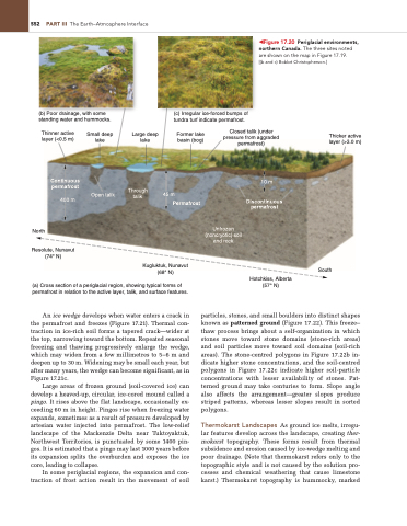
◀Figure 17.20 Periglacial environments, northern Canada. The three sites noted are shown on the map in Figure 17.19.
[(b and c) Bobbé Christopherson.]
         Open talik 400 m
45 m
10 m
Discontinuous permafrost
Hotchkiss, Alberta (57° N)
    North
Unfrozen (noncryotic) soil and rock
 Resolute, Nunavut (74° N)
(a) Cross section of a periglacial region, showing typical forms of permafrost in relation to the active layer, talik, and surface features.
An ice wedge develops when water enters a crack in the permafrost and freezes (Figure 17.21). Thermal con- traction in ice-rich soil forms a tapered crack—wider at the top, narrowing toward the bottom. Repeated seasonal freezing and thawing progressively enlarge the wedge, which may widen from a few millimetres to 5–6 m and deepen up to 30 m. Widening may be small each year, but after many years, the wedge can become significant, as in Figure 17.21c.
Large areas of frozen ground (soil-covered ice) can develop a heaved-up, circular, ice-cored mound called a pingo. It rises above the flat landscape, occasionally ex- ceeding 60 m in height. Pingos rise when freezing water expands, sometimes as a result of pressure developed by artesian water injected into permafrost. The low-relief landscape of the Mackenzie Delta near Tuktoyaktuk, Northwest Territories, is punctuated by some 1400 pin- gos. It is estimated that a pingo may last 1000 years before its expansion splits the overburden and exposes the ice core, leading to collapse.
In some periglacial regions, the expansion and con- traction of frost action result in the movement of soil
particles, stones, and small boulders into distinct shapes known as patterned ground (Figure 17.22). This freeze– thaw process brings about a self-organization in which stones move toward stone domains (stone-rich areas) and soil particles move toward soil domains (soil-rich areas). The stone-centred polygons in Figure 17.22b in- dicate higher stone concentrations, and the soil-centred polygons in Figure 17.22c indicate higher soil-particle concentrations with lesser availability of stones. Pat- terned ground may take centuries to form. Slope angle also affects the arrangement—greater slopes produce striped patterns, whereas lesser slopes result in sorted polygons.
Thermokarst Landscapes As ground ice melts, irregu- lar features develop across the landscape, creating ther- mokarst topography. These forms result from thermal subsidence and erosion caused by ice-wedge melting and poor drainage. (Note that thermokarst refers only to the topographic style and is not caused by the solution pro- cesses and chemical weathering that cause limestone karst.) Thermokarst topography is hummocky, marked
Kugluktuk, Nunavut (68° N)
South


