Page 596 - Geosystems An Introduction to Physical Geography 4th Canadian Edition
P. 596
 560 part III The earth–atmosphere interface
    Melting exposes darker surfaces along the edges of the ice sheet.
Likely causes of interior darkening are black carbon
from Arctic wildfifires settling
on snow and ice surfaces, and melting of snow crystals into clumps that absorb more sunlight than than solitary crystals.
 Percent difference
from average reflectiveness
-18 -9 0 +9 +18
 Melt zone
(meltponds and water-saturated ice)
the ice (also visible in Figure 17.30b and d, taken in southwest Greenland in 2008). Melt streams are also common dur- ing periods of warmer temperatures in glaci- ated environments, es- pecially in summer. The streams can melt through the ice sheet, form- ing moulins, or drain- age channels, that work their way to the base of the glacier (Figure 17.30d ande).
Multiple streams can flow together in summer to form a su- praglacial lake on top of the ice. When the water pressure builds to a high enough level, the ice below the lake fractures and drains the lake through a near-vertical moulin to the glacier’s bed. This drainage may result in a large volume of water arriving sud- denly at the base of the glacier. Scientists have
0 150
300 KILOMETRES
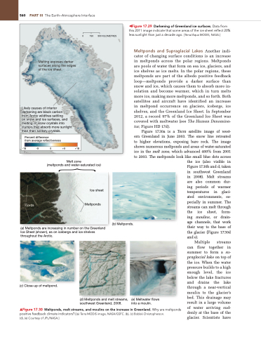
◀Figure 17.29 Darkening of Greenland ice surfaces. Data from this 2011 image indicate that some areas of the ice sheet reflect 20% less sunlight than just a decade ago. [Terra/Aqua MODiS, naSa.]
Meltponds and Supraglacial Lakes Another indi- cator of changing surface conditions is an increase in meltponds across the polar regions. Meltponds are pools of water that form on sea ice, glaciers, and ice shelves as ice melts. In the polar regions, these meltponds are part of the albedo positive feedback loop—meltponds provide a darker surface than snow and ice, which causes them to absorb more in- solation and become warmer, which in turn melts more ice, making more meltponds, and so forth. Both satellites and aircraft have identified an increase in meltpond occurrence on glaciers, icebergs, ice shelves, and the Greenland Ice Sheet. In September 2012, a record 97% of the Greenland Ice Sheet was covered with meltwater (see The Human Denomina- tor, Figure HD 17d).
Figure 17.30a is a Terra satellite image of west- ern Greenland in June 2003. The snow line retreated to higher elevations, exposing bare rock. The image shows numerous meltponds and areas of water-saturated ice in the melt zone, which advanced 400% from 2001 to 2003. The meltponds look like small blue dots across
        Fjords
Ice sheet Meltponds
(a) Meltponds are increasing in number on the Greenland Ice Sheet (shown), as on icebergs and ice shelves throughout the Arctic.
(b) Meltponds.
       (c) Close-up of meltpond.
(d) Meltponds and melt streams, southwest Greenland, 2008.
(e) Meltwater flows into a moulin.
▲Figure 17.30 Meltponds, melt streams, and moulins on the increase in Greenland. Why are meltponds positive feedback climate indicators? [(a) Terra MODiS image, naSa/gSFC. (b), (c) Bobbé Christopherson.
(d), (e) Courtesy of JPL/naSa.]
{


