Page 594 - Geosystems An Introduction to Physical Geography 4th Canadian Edition
P. 594
 558 part III The earth–atmosphere interface
Summer Lake
Albert Lake
Goose Lake
Honey Lake
Pyramid Lake
Lake Tahoe
Oregon
Idaho
Harney Lake
Malheur Lake
Alvord Lake
Nevada
Walker Lake
Lake Manly
Lake Manix
Wasatch Range
Sierra Nevada
Mono Lake
Lake Russell
California
Lake Searles
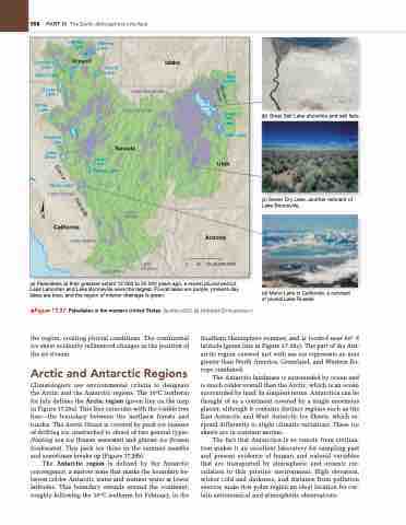
(c) Sevier Dry Lake, another remnant of Lake Bonneville.
(d) Mono Lake in California, a remnant of pluvial Lake Russell.
Carson Lake
Lake Bonneville Lake Lahontan
Bear Lake
Great Salt Lake
Utah Lake
Utah
Arizona
50 100 KILOMETRES
(b) Great Salt Lake shoreline and salt flats.
Lake Mojave
0
(a) Paleolakes at their greatest extent 12 000 to 30 000 years ago, a recent pluvial period. Lake Lahontan and Lake Bonneville were the largest. Pluvial lakes are purple, present-day lakes are blue, and the region of interior drainage is green.
▲Figure 17.27 Paleolakes in the western United States. [(a) after USgS; (b)–(d) Bobbé Christopherson.]
the region, creating pluvial conditions. The continental ice sheet evidently influenced changes in the position of the jet stream.
Arctic and Antarctic Regions
Climatologists use environmental criteria to designate the Arctic and the Antarctic regions. The 10°C isotherm for July defines the Arctic region (green line on the map in Figure 17.28a). This line coincides with the visible tree line—the boundary between the northern forests and tundra. The Arctic Ocean is covered by pack ice (masses of drifting ice, unattached to shore) of two general types: floating sea ice (frozen seawater) and glacier ice (frozen freshwater). This pack ice thins in the summer months and sometimes breaks up (Figure 17.28b).
The Antarctic region is defined by the Antarctic convergence, a narrow zone that marks the boundary be- tween colder Antarctic water and warmer water at lower latitudes. This boundary extends around the continent, roughly following the 10°C isotherm for February, in the
Southern Hemisphere summer, and is located near 60° S latitude (green line in Figure 17.28c). The part of the Ant- arctic region covered just with sea ice represents an area greater than North America, Greenland, and Western Eu- rope combined.
The Antarctic landmass is surrounded by ocean and is much colder overall than the Arctic, which is an ocean surrounded by land. In simplest terms, Antarctica can be thought of as a continent covered by a single enormous glacier, although it contains distinct regions such as the East Antarctic and West Antarctic Ice Sheets, which re- spond differently to slight climatic variations. These ice sheets are in constant motion.
The fact that Antarctica is so remote from civiliza- tion makes it an excellent laboratory for sampling past and present evidence of human and natural variables that are transported by atmospheric and oceanic cir- culation to this pristine environment. High elevation, winter cold and darkness, and distance from pollution sources make this polar region an ideal location for cer- tain astronomical and atmospheric observations.


