Page 592 - Geosystems An Introduction to Physical Geography 4th Canadian Edition
P. 592
 170°
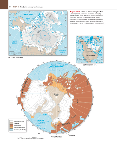
▼Figure 17.25 Extent of Pleistocene glaciation. earlier episodes produced ice sheets of slightly greater extent. note the depth of the continental ice sheets in north america (in metres). [From
a. Mcintyre, CLIMAP (Climate: Long-range investigation, Mapping, and Prediction) Project, Lamont-Doherty earth Observatory. © 1981 by the gSa. adapted by permission.]
556
part III The earth–atmosphere interface
70°
70°
80°
180°
170°
150°
140°
0 250 500 KILOMETRES
130°
(a) 18 000 years ago.
ARCTIC OCEAN
Beaufort Sea
Baffin Bay
Hudson Bay
20°
30°
40°
50°
60°
ATLANTIC OCEAN
70°
60°
60°
3000 m
60°
1000 m
2000 m 3000 m
2000 m
50°
50°
PACIFIC OCEAN
Alaska
60°
40°
40°
40°
40°
30°
30°
180°
Prime Meridian
Equator
170°
170°
160°
160°
a
50°
50°
150°
150°
140°
140°
130°
130°
120°
A
120°
C
I
Beijing
R
E
110°
M
110°
A
H
T
100°
R
O
100°
N
90°W
90°E
ASIA
80°
80°
70°
70°
60°
60°
Moscow
Continental ice Sea ice Continents Glacial maximum Oceans (0°–24°C)
8°–12°C 50° 12°–16°C
50°
50°
a
e
S
EUROPE
k
c
l
40°
B
30°
20°
(b) Polar perspective, 18 000 years ago.
0°– 4°C
NORTH 4°– 8°C ATLANTIC
North Pole
80°
70°
60°
8°–12°C 12°–16°C 16°–20°C 4°– 8°C NORTH PACIFIC
(c) 9 000 years ago.
0°– 4°C
W 0° E
170°
ARCTIC OCEAN
CANADA
UNITED STATES
PACIFIC OCEAN
0
500 KILOMETRES
Gulf of Mexico
130°
ATLANTIC OCEAN
70°
120°
MEXICO
GREENLAND
40°
30°
20°
10°
10°


