Page 593 - Geosystems An Introduction to Physical Geography 4th Canadian Edition
P. 593
 Lake Agassiz
(a)
(b)
Lake Winnipegosis Dauphin Lake
Lake Winnipeg
Lake Keweenaw
Lake Manitoba
250 KILOMETRES
Extent of Glacial Lake Agassiz
Lake Agassiz
Lake Agassiz
11 800 Years B.P.
Early Lake Erie
10 000 Years B.P.
Champlain Sea
Lake Chicago
Cedar Lake
Hudson Bay
Lake of the Woods
Lake Chicago
Lake Minong
Lake Chippewa
Lake Ontario Lake Erie
13 200 Years B.P.
Lake
Saginaw Lake
Whittlesey
12 500 Years B.P.
Chapter 17 glacial and Periglacial Landscapes 557 11 000 Years B.P.
Lake Algonquin
Early Lake Iroquois
Early
L. Nipissing
Lake Stanley
Lake Barlow
Lake Hough
Champlain Sea
(c)
(d)
late Pleistocene paleolakes were Lake Bonneville and Lake Lahontan, located in the Basin and Range Province in the western United States. These two lakes were much larger than their present-day remnants.
The Great Salt Lake, near Salt Lake City, Utah, and the Bonneville Salt Flats in western Utah are remnants of Lake Bonneville; today, the Great Salt Lake is the fourth largest saline lake in the world. At its greatest extent, this paleolake covered more than 50000 km2 and reached
Early Lake Erie
0
125
Early Lake Ontario
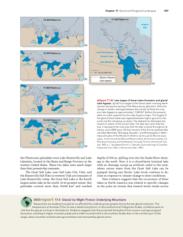
▲Figure 17.26 Late stages of Great Lakes formation and glacial Lake Agassiz. (a)–(d) Four stages of the great Lakes’ evolving devel- opment during the waning of the Wisconsinan glaciation. note the change in stream drainage between (b) and (d). (e) note the mas- sive Lake agassiz at approximately 11 000 B.P. (before the present), when an outlet opened into the Lake Superior basin. The largest of the glacial great Lakes was trapped between higher ground to the south and the retreating ice sheet. The dashed line delineates the maximum extent of the ancient lake. The lake was never fully this size; it represents the total area that the lake covered throughout its history, some 4000 years. all that remains of the former greatest lake are lakes Manitoba, Winnipeg, Dauphin, and Winnipegosis in Mani- toba and Lake of the Woods in Ontario. [(a) through (d) After the Great Lakes—An Environmental Atlas and Resource Book, environment Canada, U.S. ePa, Brock University, and northwestern University (Toronto: environment Can- ada, 1987), p. 7. (e) adapted from a. S. Trenhaile, geomorphology: a Canadian Perspective, from Teller, in Karrow and Calkin, 1985.]
depths of 300 m, spilling over into the Snake River drain- age to the north. Now, it is a closed-basin terminal lake with no drainage except an artificial outlet to the west, where excess water from the Great Salt Lake can be pumped during rare floods. Lake levels continue to de- cline in response to climate change to drier conditions.
New evidence suggests that the occurrence of these lakes in North America was related to specific changes in the polar jet stream that steered storm tracks across
Georeport 17.4 Glacial Ice Might Protect Underlying Mountains
researchers are studying how glacial ice affected the underlying topography during the last glacial maximum. The temperature at the base of the ice was a determining factor. in the southernmost Patagonian andes, conditions were so
cold that the glacial ice froze to the bedrock. evidence suggests that this protected the bedrock from erosion and typical glacial excavation, resulting in higher mountain peaks and a wider mountain belt in the southern andes than in the northern part of the range, where mountain surfaces were ground down and narrowed by glacial action.
(e)


