Page 609 - Geosystems An Introduction to Physical Geography 4th Canadian Edition
P. 609
Chapter 18 The Geography of Soils 573
     Thicker soils develop on plateaus and in valleys
Soils on north-facing slopes hold more moisture
Thinner soils develop on steep slopes
Soils on south-facing slopes are drier
         ▲Figure 18.1 Relationships between topography and soil development. [Kevin Ebi/Alamy.]
into new areas and alter natural vegetation by logging or ploughing, the affected soils are likewise altered, often permanently.
Relief and topography also affect soil formation (Figure 18.1). Slopes that are too steep cannot have full soil development, because gravity and erosional pro- cesses remove materials. Lands that are level or nearly level tend to develop thicker soils, but may be subject to soil drainage issues such as waterlogging. The ori- entation of slopes relative to the Sun is also important, because it controls exposure to sunlight. In the Northern Hemisphere, a south-facing slope is warmer overall through the year because it receives direct sunlight. North-facing slopes are colder, causing slower snow- melt and a lower evaporation rate, thus providing more
Soil pedon
moisture for plants than is available on south-facing slopes, which tend to dry out faster.
All of the identified natural factors in soil develop- ment require time to operate. Over geologic time, plate tectonics has redistributed landscapes and thus subjected soil-forming processes to diverse conditions. The rate of soil development is closely tied to the nature of the parent material (soils develop more quickly from sediments than from bedrock) and to climate (soils develop at a faster rate in warm, humid climates).
Soil Horizons
As a book cannot be judged by its cover, so soils cannot be evaluated at the ground surface only. Instead, scien- tists evaluate soils using a soil profile, a vertical section of soil that extends from the surface to the deepest extent of plant roots or to the point where regolith or bedrock is encountered. Soil profiles may be exposed by human activities, such as at a construction site or excavation, or along a highway road cut. When soil is not exposed by natural processes or human activity, scientists dig soil pits to expose a soil profile for analysis.
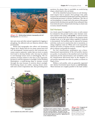
For soil classification, pedologists use a three- dimensional representation of the soil profile, known as a pedon. A soil pedon is the smallest unit of soil that represents all the characteristics and variability used for classification (discussed later in the chapter). A soil profile represents one side of a pedon, as shown in Figure 18.2a.
Within a soil profile, soils are generally organized into distinct horizontal layers known as soil horizons. These horizons are roughly parallel to the land surface
Soil horizons O and A
Ae
B
C
(b) Gleysol from southern Ontario. The parent material is till and glaciolacustrine sediment, and the soil is poorly drained. The dark O an Ae horizons are above the #7 and the transition into the Ae horizon spans to the #13. Below the #13 is the mottled B horizon.
   Soil horizons
O A
Ae B
C
R
 Soil profile
(a) An idealized soil profile within a pedon.
◀Figure 18.2 A typical soil profile within a pedon,
and example. [Reproduced with the permission of the Minister of Agriculture and Agri-Food Canada, 2015.]
Solum


