Page 617 - Geosystems An Introduction to Physical Geography 4th Canadian Edition
P. 617
    Chapter 18 The Geography of Soils 581
    60°
30°
0°
150° 120° 90° 60° 30° 0° 30° 60° 90° 120° 150°
  30°
60°
RISK Low
Moderate
High
Very high
Not considered
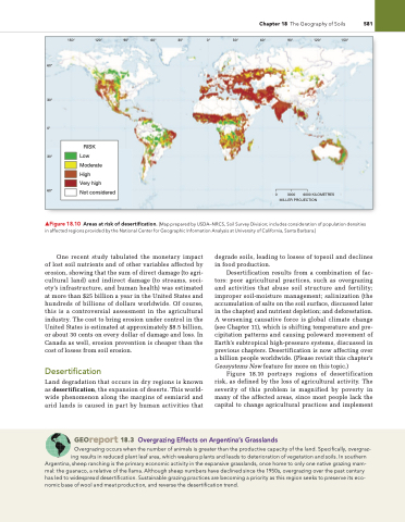
  ▲Figure 18.10 Areas at risk of desertification. [Map prepared by USDA–NRCS, Soil Survey Division; includes consideration of population densities in affected regions provided by the National Center for Geographic information Analysis at University of California, Santa Barbara.]
One recent study tabulated the monetary impact of lost soil nutrients and of other variables affected by erosion, showing that the sum of direct damage (to agri- cultural land) and indirect damage (to streams, soci- ety’s infrastructure, and human health) was estimated at more than $25 billion a year in the United States and hundreds of billions of dollars worldwide. Of course, this is a controversial assessment in the agricultural industry. The cost to bring erosion under control in the United States is estimated at approximately $8.5 billion, or about 30 cents on every dollar of damage and loss. In Canada as well, erosion prevention is cheaper than the cost of losses from soil erosion.
Desertification
Land degradation that occurs in dry regions is known as desertification, the expansion of deserts. This world- wide phenomenon along the margins of semiarid and arid lands is caused in part by human activities that
degrade soils, leading to losses of topsoil and declines in food production.
Desertification results from a combination of fac- tors: poor agricultural practices, such as overgrazing and activities that abuse soil structure and fertility; improper soil-moisture management; salinization (the accumulation of salts on the soil surface, discussed later in the chapter) and nutrient depletion; and deforestation. A worsening causative force is global climate change (see Chapter 11), which is shifting temperature and pre- cipitation patterns and causing poleward movement of Earth’s subtropical high-pressure systems, discussed in previous chapters. Desertification is now affecting over a billion people worldwide. (Please revisit this chapter’s Geosystems Now feature for more on this topic.)
Figure 18.10 portrays regions of desertification risk, as defined by the loss of agricultural activity. The severity of this problem is magnified by poverty in many of the affected areas, since most people lack the capital to change agricultural practices and implement
0 3000 6000 KILOMETRES MILLER PROJECTION
 Georeport 18.3 Overgrazing Effects on Argentina’s grasslands
Overgrazing occurs when the number of animals is greater than the productive capacity of the land. Specifically, overgraz- ing results in reduced plant leaf area, which weakens plants and leads to deterioration of vegetation and soils. in southern Argentina, sheep ranching is the primary economic activity in the expansive grasslands, once home to only one native grazing mam-
mal: the guanaco, a relative of the llama. Although sheep numbers have declined since the 1950s, overgrazing over the past century has led to widespread desertification. Sustainable grazing practices are becoming a priority as this region seeks to preserve its eco- nomic base of wool and meat production, and reverse the desertification trend.


