Page 668 - Geosystems An Introduction to Physical Geography 4th Canadian Edition
P. 668
 632 part IV Soils, ecosystems, and Biomes
F cus Study 19.2 Environmental Restoration Ecosystems of the Great lakes
The great lakes—Superior, Michigan, Huron, erie, and Ontario—contain 18%
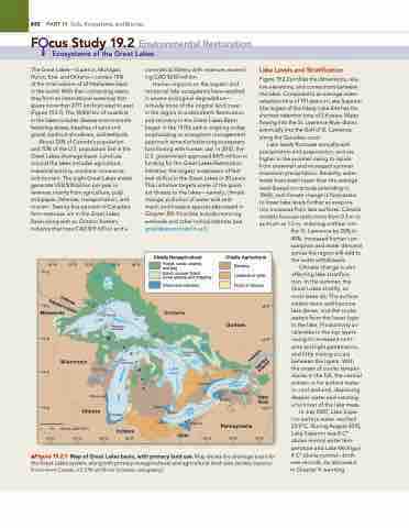
of the total volume of all freshwater lakes in the world. With their connecting rivers, they form an international waterway that spans more than 2771 km from west to east (Figure 19.2.1). The 18 000 km of coastline in the lakes includes diverse environments featuring dunes, beaches of sand and gravel, bedrock shorelines, and wetlands.
about 25% of Canada’s population and 10% of the U.S. population live in the great lakes drainage basin. land use around the lakes includes agriculture, industrial activity, maritime commerce, and tourism. The eight great lakes states generate USD $18 billion per year in revenue, mainly from agriculture, pulp and paper, fisheries, transportation, and tourism. Twenty-five percent of Canada’s farm revenues are in the great lakes Basin along with an Ontario forestry industry that tops CaD $19 billion and a
commercial fishery with revenues exceed- ing CaD $250 million.
Human impacts on the aquatic and terrestrial lake ecosystems have resulted in severe ecological degradation— virtually none of the original land cover
in the region is undisturbed. restoration and recovery in the great lakes Basin began in the 1970s and is ongoing today, emphasizing an ecosystem management approach aimed at balancing ecosystem functioning with human use. in 2010, the U.S. government approved $475 million in funding for the great lakes restoration initiative, the largest investment of fed- eral dollars in the great lakes in 20 years. This initiative targets some of the great- est threats to the lakes—namely, climate change, pollution of water and sedi- ment, and invasive species (discussed in Chapter 20). Priorities include restoring wetlands and other critical habitats (see greatlakesrestoration.us/).
lake levels and stratification
Figure 19.2.2 profiles the dimensions, rela- tive elevations, and connections between the lakes. Compared to an average water- retention time of 191 years in lake Superior (the largest of the lakes), lake erie has the shortest retention time of 2.6 years. Water flowing into the St. lawrence river drains eventually into the gulf of St. lawrence along the Canadian coast.
lake levels fluctuate annually with precipitation and evaporation, and are higher in the summer owing to inputs from snowmelt and increased summer maximum precipitation. recently, water levels have been lower than the average level (based on records extending to 1860), and climate change is forecasted to lower lake levels further as evapora- tion increases from lake surfaces. Climate models forecast reductions from 0.3 m to as much as 1.5 m, reducing outflow into
50°N
C
A
N
U
A
D
N
A
I
T
E
48°N
D
S
T
A
T
r
E
S
e
k
48°N
a
L
S
u
p
e
i
o
r
46°N
46°N
C
M
i
l
e
n
N
o
c
r
t
h
h
a
n
.
R
e
c
h
n
e
r
w
a
CANADA
UNITED STATES
y
t
.
i
Ba
S
n
e
e
r
G
n
g
a
g
i
44°N
h
y
a
c
i
B
a
w
Lake Ontario
a
M
n
i
g
a
L
S
n
e
k
a
L
42°N
Lake Erie
42°N
0
94°W 92°W 90°W Nipigon
88°W
86°W
84°W
Fores8t2, °sWcrub, sw8a0m°Wp,
and bog
Scrub, cutover forest, some grazing and cropping
78°W
Minnesota
Isle Royale
Duluth
Wisconsin
Keweenaw Peninsula
Illinois
75 150 KILOMETRES
92°W 90°W 88°W
Cleveland
Buffalo
Pennsylvania
78°W
York
76°W
Thunder Bay
Urban and suburban
Ontario
Lake
Green Bay
Lake Winnebago
Milwaukee
Lake Huron
Lake St. Clair
Windsor
Lake Simcoe
Door Peninsula
Chicago
Indiana
86°W
Manitoulin Island
Georgian Bay
▲Figure 19.2.1 Map of Great lakes basin, with primary land use. Map shows the drainage basin for the great lakes system, along with primary nonagricultural and agricultural land uses. [(a) Map based on environment Canada, U.S. ePa and Brock University cartography.]
Chiefly Nonagricultural
Chiefly Agricultural
76°W 74°W Dairying
50°N Livestock or grain
Fruits or tobacco
Québec
Kingston
Niagara
Falls New
the St. lawrence by 20% to 40%. increased human con- sumption and water demand across the region will add to the water withdrawals.
Climate change is also affecting lake stratifica- tion. in the summer, the great lakes stratify, as most lakes do: The surface waters warm and become less dense, and the cooler waters form the lower layer in the lake. Productivity ac- celerates in the top layers owing to increased nutri- ents and light penetration, and little mixing occurs between the layers. With the onset of cooler temper- atures in the fall, the normal pattern is for surface water to cool and sink, displacing deeper water and creating a turnover of the lake mass.
in July 2007, lake Supe- rior surface water reached 23.9°C. During august 2010, lake Superior was 8 C° above normal water tem- perature and lake Michigan 4 C° above normal—both
new records. as discussed in Chapter 9, warming
Sault
Ste. Marie
Detroit Toledo
Lake Nipissing
Ohio
80°W
Toronto
Rochester


