
Page 239 - NGTU_paper_withoutVideo
P. 239
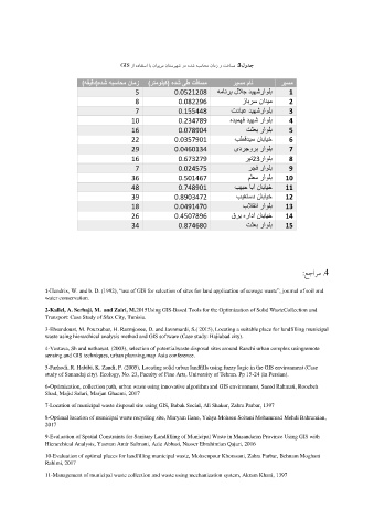
GIS  زا هدافتسا اب ناویرم ناتسرهش رد هدش هبساحم نامز و تفاسم  3 :    لودج

                            )هقیقد(هدش هبساحم نامز    )رتمولیک( هدش  یط تفاسم    ریسم مان    ریسم
                                            5             0.0521208     همانرب للاج دیهشراولب  1
                                            8              0.082296            زابرس نادیم   2
                                            7              0.155448         تدابع دیهشراولب  3
                                            10             0.234789         هدیمهف دیهش راولب  4
                                            16             0.078904              تثعب راولب  5

                                            22            0.0357901          بطقدیس نابایخ   6
                                            29            0.0460134          یدرجورب راولب   7

                                            16             0.673279             ریت 23 راولب  8
                                            7              0.024575              رجف راولب   9
                                            36             0.501467              ملعم راولب    10

                                            48             0.748901          بیبح ابا نابایخ    11
                                            39            0.8903472           بیغتسد نابایخ    12

                                            18            0.0491470             بلاقنا راولب    13
                                            26            0.4507896         قرب هرادا نابایخ    14
                                            34             0.874680              تثعب راولب    15


                                                                                                 :عجارم . 4

               1-Hendrix, W. and b. D. (1992), “use of GIS for selection of sites for land application of sewage waste”, journal of soil and
               water conservation.


               2-Kallel, A. Serbaji, M.  and Zairi, M.2015Using GIS-Based Tools for the Optimization of Solid WasteCollection and
               Transport: Case Study of Sfax City, Tunisia.
               3-Ehsandoust, M. Pourxabaz, H. Razmjooee, D. and Javnmardi, S.( 2015), Locating a suitable place for landfilling municipal
               waste using hierarchical analysis method and GIS software (Case study: Hajiabad city).
               4-Vastava, Sh and nathawat. (2003), selection of potentialwaste disposal sites around Ranchi urban complex usingremote
               sensing and GIS techniques, urban planning,map Asia conference.
               5-Farhodi, R. Habibi, K. Zandi, P. (2005), Locating solid urban landfills using fuzzy logic in the GIS environment (Case
               study of Sanandaj city). Ecology, No. 23, Faculty of Fine Arts, University of Tehran. Pp 15-24 (in Persian).
               6-Optimization, collection path, urban waste using innovative algorithm and GIS environment, Saeed Rahmati, Roozbeh
               Shad, Majid Salari, Marjan Ghaemi, 2017
               7-Location of municipal waste disposal site using GIS, Babak Social, Ali Shakur, Zahra Parbar, 1397
               8-Optimal location of municipal waste recycling site, Maryam Ilano, Yahya Mohsen Soltani Mohammad Mehdi Bahramian,
               2017
               9-Evaluation of Spatial Constraints for Sanitary Landfilling of Municipal Waste in Mazandaran Province Using GIS with
               Hierarchical Analysis, Yasman Amir Salmani, Aziz Abbasi, Nasser Ebrahimian Qajari, 2016
               10-Evaluation of optimal places for landfilling municipal waste, Mohsenpour Khorasani, Zahra Parbar, Behnam Moghani
               Rahimi, 2017

               11-Management of municipal waste collection and waste using mechanization system, Akram Khani, 1397