
Page 563 - NGTU_paper_withoutVideo
P. 563
کیتاموئژ نیون یاهدربراک و اه یروآ نف یلم سنارفنک
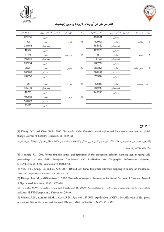
)رات که( تداسم یزوس شتآ کسیر هقبط ناتسرهش فیدر )راتکه( تداسم یزوس شتآ کسیر هقبط ناتسرهش فیدر
229765 ینارحب 199801 ینارحب
1121 یداع درمال 25 40972 یداع اراد 11
334968 ینارحب همین 485150 ینارحب همین
42597 ینارحب 128325 ینارحب
41146 یداع تشدورم 26 45 یداع متسر 12
162850 ینارحب همین 16102 ینارحب همین
158294 ینارحب 84709 ینارحب
2924 یداع ینسمم 27 27332 یداع تشد نيرز 13
108835 ینارحب همین 361159 ینارحب همین
439755 ینارحب 78326 ینارحب
95 یداع رهم 23 49588 یداع نادیپس 14
132726 ینارحب همین 83075 ینارحب همین
40706 ینارحب 148393 ینارحب
490822 یداع زيرین 29
547076 ینارحب همین
23110 ینارحب
عجارم 1 .
[1] Zhang, Q.F. and Chen, W.J., 2007. Fire cycle of the Canada's boreal region and its potential response to global
change. Journal of Forestry Research, 18 (1):55-61
دادرخ ،نارهت کیتاموئژ شيامه ،یناکم تاعالطا یاه هناماس زا هدافتسا اب لگنج یزوس شتآ یزاس هیبش : 1334 .داهرف،یلعنیسح و یلع دمحم ،یبجر ] [ 2
. دیفس هدنرپ تالاقم کناب، 1334
[3] Almedia, R., 1994. Forest fire risk areas and definition of the prevention priority planning actions using GIS
proceedings of the Fifth European Conference and Exhibitiion on Geographic Information Systems,
EGIS94.Utrecht:EGIS Foundation, 2:1700-1706.
[4] Yin, H.W., Kong, F.H. and Li, X.Z., 2004. RS and GIS-based forest fire risk zone mapping in dahinggan mountains.
Chinese Geographical Science, 14 (3): 251-257.
[5] Dimopoulou, M. and Giannikos, I., 2002. Towards anintegrated framework for forest fire control.European Journal
of Operational Research,152 (2): 476-486.
[6] Bevrly, M.W., Buckley, D.J., and Strickland. R. 2009. Automation of visible area mapping for fire detection
lookouts, GIS'90 Symposium, Vancouver, 29-46.
[7] Jaiswal, A.K., Kimothi, M.M., Jadhav, R.N., Agarwal, J.P.,2001. Application of GIS in identification of fire prone
areas feasibility study in parts of Junagarh (Gujrat, India). Indian For. 124 (7), 531–535.