Page 256 - Guerin Media | The Wild Atlantic Way
P. 256
Donegal
Dún na nGall
In terms of size and area, it is the largest county in natural sea loughs, of which both Lough Swilly and
Ulster and the fourth-largest county in all of Ireland. Lough Foyle are the most notable. The Slieve League
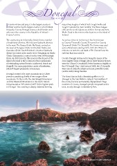
Uniquely, County Donegal shares a small border with cliffs are the sixth-highest sea cliffs in Europe and here,
only one other county in the Republic of Ireland – Malin Head is the most northerly point on the island of
County Leitrim. Ireland.
The county may be informally divided into a number At various times in its history, it has been known
of traditional districts. We find two Gaeltacht districts as County Tirconaill, County Tirconnell or County
in the west: The Rosses (Irish: Na Rosa), centred on Tyrconnell (Irish: Tír Chonaill). The former was used
the town of Dungloe (Irish: An Clochán Liath), and as its official name during 1922–1927.[21] This is in
Gweedore (Irish: Gaoth Dobhair). Another Gaeltacht reference to both the old túath of Tír Chonaill and the
district is located in the north-west: Cloughaneely (Irish: earldom that succeeded it.
Cloich Chionnaola), centred on the town of Falcarragh County Donegal is famous for being the home of the
(Irish: An Fál Carrach). The most northerly part of the once mighty Clann Dálaigh, whose most famous branch
island of Ireland is the location for three peninsulas were the Clann Ó Domhnaill, better known in English as
of outstanding natural beauty: Inishowen, Fanad and the O’Donnell Clan. Until around 1600, the O’Donnells
Rosguill. The main population centre of Inishowen, were one of Ireland’s richest and most powerful Gaelic
Ireland’s largest peninsula, is Buncrana. (native Irish) ruling-families.
Donegal county is the most mountainous in Ulster The Great Famine had a devastating effect on Co.
province,consisting chiefly of two ranges of low Donegal in the late 1840s in Ireland. Vast swathes of
mountains. To the north, the Derryveagh Mountains the county became permanently depopulated. Huge
and the Bluestack Mountains to the south. Mount numbers of County Donegal’s people emigrated at this
Errigal stands at 749 metres (2,457 ft) the highest peak time, mostly through Londonderry Port.
in Donegal. The coastling is deeply indented forming
Dusk at Fanad © Chris Ibbotson
254
Dún na nGall
In terms of size and area, it is the largest county in natural sea loughs, of which both Lough Swilly and
Ulster and the fourth-largest county in all of Ireland. Lough Foyle are the most notable. The Slieve League
Uniquely, County Donegal shares a small border with cliffs are the sixth-highest sea cliffs in Europe and here,
only one other county in the Republic of Ireland – Malin Head is the most northerly point on the island of
County Leitrim. Ireland.
The county may be informally divided into a number At various times in its history, it has been known
of traditional districts. We find two Gaeltacht districts as County Tirconaill, County Tirconnell or County
in the west: The Rosses (Irish: Na Rosa), centred on Tyrconnell (Irish: Tír Chonaill). The former was used
the town of Dungloe (Irish: An Clochán Liath), and as its official name during 1922–1927.[21] This is in
Gweedore (Irish: Gaoth Dobhair). Another Gaeltacht reference to both the old túath of Tír Chonaill and the
district is located in the north-west: Cloughaneely (Irish: earldom that succeeded it.
Cloich Chionnaola), centred on the town of Falcarragh County Donegal is famous for being the home of the
(Irish: An Fál Carrach). The most northerly part of the once mighty Clann Dálaigh, whose most famous branch
island of Ireland is the location for three peninsulas were the Clann Ó Domhnaill, better known in English as
of outstanding natural beauty: Inishowen, Fanad and the O’Donnell Clan. Until around 1600, the O’Donnells
Rosguill. The main population centre of Inishowen, were one of Ireland’s richest and most powerful Gaelic
Ireland’s largest peninsula, is Buncrana. (native Irish) ruling-families.
Donegal county is the most mountainous in Ulster The Great Famine had a devastating effect on Co.
province,consisting chiefly of two ranges of low Donegal in the late 1840s in Ireland. Vast swathes of
mountains. To the north, the Derryveagh Mountains the county became permanently depopulated. Huge
and the Bluestack Mountains to the south. Mount numbers of County Donegal’s people emigrated at this
Errigal stands at 749 metres (2,457 ft) the highest peak time, mostly through Londonderry Port.
in Donegal. The coastling is deeply indented forming
Dusk at Fanad © Chris Ibbotson
254