
Page 19 - High Knob Master Plan
P. 19
ASSET CATALOGUE
The Assets Action Team collected and cataloged the abundant natural, cultural, and economic resources of the High Knob Region. This catalogue will continue to grow as new outdoor recreation destinations and businesses emerge out of High Knob Regional Initiative (HKRI). In addition, the many historic, cultural, and natural resources related stories and images will continue to grow in the HKRI archive to be openly shared with those living within or visiting the region. Dive into the resources by visiting the following website: http://friendsofswva.org/
GOOGLE EARTH MAPPING
The Forest Service, Wise County, Lee County, Scott County, and other jurisdictions each have their own GIS data systems, which do not share the same platform. The lack of a consistent mapping system has limited the ability to relate multi-jurisdictional data, often creating challenges for past regional projects.
The Assets Action Team developed a Google Earth mapping tool that compiles and integrates the numerous data layers for natural, cultural, and economic assets in the High Knob Region. This user-friendly tool graphically shows the locations of all existing assets and their spatial relationships to each other. Users can easily manipulate the map, turning on and off certain data layers as needed.
Decision makers can use this tool to identify future outdoor recreation projects, assess potential environmental impacts, and strengthen connections between existing assets. Likewise, visitors can use the tool to create trail maps to help plan their trip to the region. The mapping tool can be updated as new assets are identified, creating a comprehensive catalogue that can be used for creating marketing materials and visitor maps, building connections, and encouraging private-public partnerships around shared assets.
The Asset Action Team must annually check for updates through collaboration with the multitude of stakeholders involved. This includes the addition or relocation of businesses, hotels, restaurants, etc. as well as new trails, river access points, scenic routes, etc. The layers can by edited using geographic information systems to convert shapefiles into KMZ files which can be viewed and easily shared using Google Earth.
Two versions of this Google Earth mapping tool will cater to two different user groups: stewards and visitors. The tool will be populated with different data layers that will appeal to each distinct set of users.
MAPPING FOR STEWARDS
The Google Earth mapping tool for stewards and economic developers will include the full complement of data layers including environmental resources, tourism resources, and tax map lines (where available) providing the capability to create a wide array of maps. Due to the size of the region and the amount of data collected, the data layers are large and may require a powerful computer. Data layers consist of land use, management, and ownership as well as block group level population, traffic patterns, political boundaries, buildings, roads. water bodies, and floodplains. The layers can be turned on and off as needed and can may be paired with other tourism-based data as highlighted in the following section. The layers exist as KMZ files, which can be obtained by requesting them from the Friends of Southwest Virginia (SWVA) webpage contact form or by email at info@friendsofswva.org to obtain login information to the digital asset management system.
MAPPING FOR VISITORS
The Google Earth mapping tool for visitors includes a reduced, more streamlined version of data layers that cater to the interests of tourists. This includes points of interest such as trailheads, river access points, campgrounds, scenic locations such as birdwatching or scenic routes, and other tourism assets such as the Spearhead Trails. These data layers can be opened on any computer or device with the free Google Earth application which automatically zooms to the extent of the data layers. Each point, line, or polygon can be clicked to view more attributes of the data layer being utilized. To use the mapping tool for visitors, click to the following website and locate the High Knob webpage: http://friendsofswva.org/
In addition to the digital map links, a simple user-friendly map has been created, highlighting some of the more-frequently visited sites in the region. This map is available at hotels, libraries and town halls.
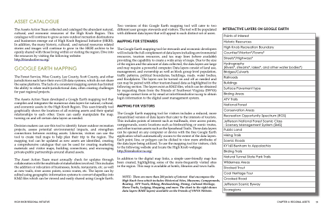
NOTE: There are more than 280 points of interest that encompass the High Knob Area which includes: Historical Sites, Museums, Campgrounds, Boating, ATV Trails, Hiking, Birdwatching, Dining, Cultural Heritage, Horse Trails, Lodging, Shopping, and more. The chart to the right shows data layers (KMZ layers) available on the Friends of SWVA Website.
INTERACTIVE LAYERS ON GOOGLE EARTH
Points of Interest
Historic Resources
High Knob Recreation Boundary
Counties*/Norton*/Towns*
Streets*/Highways*
Hydrography
(Rivers*, streams*, lakes*, and other water bodies*)
Bridges/Culverts
Railroads
Buildings
Surface Pavement type
Birding Areas
ATV Trails
National Forest
Conservation Areas
Recreation Opportunity Spectrum (ROS)
Jefferson National Forest Scenic Class - Scenery Management System (SMS)
Public Land
Hiking Trails
Scenic Roads
KY160 Benham to Appalachia
Birding Trails
Natural Tunnel State Park Trails
Wilderness Areas
Stocked Trout
Coal Heritage Tour
Crooked Road
Jefferson Scenic Byway
Ecoregions
HIGH KNOB REGIONAL INITIATIVE
CHAPTER 4: REGIONAL ASSETS 19
