
Page 26 - Wood Plenty, Grass Good, Water None
P. 26
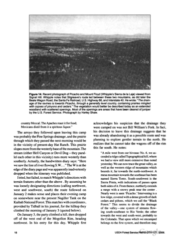
  Figure 14. Recent photograph of Picacho and Mount Floyd (Whipple's Sierra de la Laja) viewed from Signal Hill. Whipple notes that Sitgreave's route led between these two mountains, as did later the BealeWagon Road,theSantaFeRailroad,U.S.Highway66,andInterstate40.Hewrote:"Thedrain age of the ravines is towards Picacho, through a generally level country, containing prairies mingled with copses ofpinyons and cedars." The vegetation would better be described today as an extended woodland with scattered openings. Most ofthe openings are areas that have been cleared ofjuniper by the U.S. Forest Service. Photograph by Harley Shaw.
country Mezcal .The Apaches roast itfor food; Mexicans distil from ita spiritous liquor."
The arroyo they followed upon leaving this camp was probably the Pine Springs drainage, and the prairie through which they passed the next morning would be in the vicinity of present-day Hat Ranch. This prairie slopesmorefromthewesterlybaseofthemountain.The stream (either Hell Canyon or Devil D o g — they paral lel each other in this vicinity) runs more westerly than southerly. Actually, the handwritten diary says: "Here wesawthelineofriverflowingS.W...."TheW isatthe edgeofthediarypageandwasapparentlyinadvertently dropped when the itinerary was published.
Itried,butfailed,tomatch Whipple's directionswith terrain features other than the above .By assuming he was loosely designating directions (calling northwest, west and southwest, south) the route followed on January2makessenseandplacestheireveningcamp on somewhere near the present Nagiller Tank on the Kaibab National Forest. This matches with coordinates, provided by Tidball in his journal, for the hilltop they climbed the morning of January 3 (quoted below).
On January3,thepartyclimbedahill,thendropped off of the west end of the Mogollon Rim, heading northwest. In his entry for this day, Whipple first
acknowledges his suspicion that the drainage they were camped on was not Bill William's Fork. In fact, his decision to leave this drainage suggests that he was already abandoning itas a possible route and was planning to explore gentler terrain to the north. He realizes that he cannot take the wagons off of the rim this far south. He notes:
"A mile west from our bivouac No. 4, we as
cended aridgecalledTopographical hill,where
w e h a d a v i e w still m o r e e x t e n s i v e t h a n n o t e d
yesterday.We cannow tracethegreatvalley,as
well as the western ridge of mountains which
bounds it,far towards the north-northwest. A
mesa mountain towards the southeast has been
named Sierra Tonto. South-southwest is the
Sierra Prieta, with indications of passes upon
b o t h s i d e s o f it. F r o m t h e n c e , n o r t h e r l y e x t e n d s
a range with a snowy peak near the center . Nearly west is seen erPicacho.' Intervening is a
low ridge, covered with a dense growth of dark cedars and pinons, which we call the "Black Forest." This seems to divide the drainage of the valley— one system of streams flow ing south-southeast to Rio Verde; the other towards the west and south-west, probably to the Colorado. That upon which we encamped belongs to the first system, and therefore m a y
 18
USDAForestServiceRMRS-GTR-177. 2006.
