
Page 25 - The Silver Fire
P. 25
THE BLACK RANGE RAG - WWW.BLACKRANGE.ORG
Evening Update - Forest Service Release of June 15 (Con’t)
Relatively high humidity and cloud cover moderated fire behavior and minimized fire spread throughout the day. Crews completed additional burnout operations around the Kingston fuel break. 21,800 acres. 5% contained.
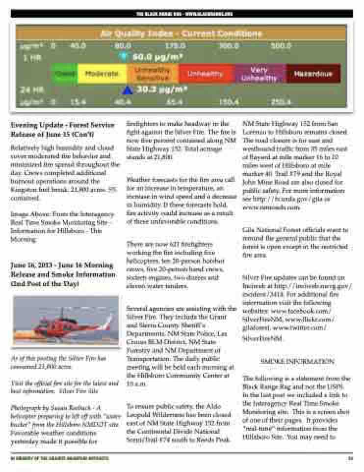
Image Above: From the Interagency Real Time Smoke Monitoring Site - Information for Hillsboro - This Morning
June 16, 2013 - June 16 Morning Release and Smoke Information (2nd Post of the Day)
As of this posting the Silver Fire has consumed 21,800 acres.
Visit the official fire site for the latest and best information: Silver Fire Site
Photograph by Susan Roebuck - A helicopter preparing to lift off with “water bucket” from the Hillsboro NMDOT site. Favorable weather conditions yesterday made it possible for
firefighters to make headway in the fight against the Silver Fire. The fire is now five percent contained along NM State Highway 152. Total acreage stands at 21,800.
Weather forecasts for the fire area call for an increase in temperature, an increase in wind speed and a decrease in humidity. If these forecasts hold, fire activity could increase as a result of these unfavorable conditions.
There are now 621 firefighters working the fire including five helicopters, ten 20-person hotshot crews, five 20-person hand crews, sixteen engines, two dozers and eleven water tenders.
Several agencies are assisting with the Silver Fire. They include the Grant and Sierra County Sheriff’s Departments, NM State Police, Las Cruces BLM District, NM State Forestry and NM Department of Transportation. The daily public meeting will be held each morning at the Hillsboro Community Center at 10 a.m.
To ensure public safety, the Aldo Leopold Wilderness has been closed east of NM State Highway 152 from the Continental Divide National ScenicTrail #74 south to Reeds Peak.
NM State Highway 152 from San Lorenzo to Hillsboro remains closed. The road closure is for east and westbound traffic from 35 miles east of Bayard at mile marker 16 to 10 miles west of Hillsboro at mile marker 40. Trail #79 and the Royal John Mine Road are also closed for public safety. For more information see http://fs.usda.gov/gila or www.nmroads.com.
Gila National Forest officials want to remind the general public that the forest is open except in the restricted fire area.
Silver Fire updates can be found on Inciweb at http://inciweb.nwcg.gov/ incident/3414. For additional fire information visit the following websites: www.facebook.com/ SilverFireNM, www.flickr.com/ gilaforest, www.twitter.com/
SilverFireNM.
SMOKE INFORMATION
The following is a statement from the Black Range Rag and not the USFS. In the last post we included a link to the Interagency Real Time Smoke Monitoring site. This is a screen shot of one of their pages. It provides “real-time” information from the Hillsboro Site. You may need to
IN MEMORY OF THE GRANITE MOUNTAIN HOTSHOTS
25
