
Page 62 - The Silver Fire
P. 62
THE BLACK RANGE RAG - WWW.BLACKRANGE.ORG
The Long View (Con’t)
on and joins the river between the south end of Caballo Lake and Arrey.
5. Trujillo Canyon begins up there on the east-facing slopes of Sawyer’s Peak. Waters from Trujillo Canyon join the river at Arrey.
6. Tierra Blanca originates around Sawyer’s Peak and a bit south, and joins the river south of Arrey.
The Rio Grande flows to the Gulf of Mexico at Brownsville, Texas and starts as a trout-filled mountain freshet in the San Juans of southern Colorado.
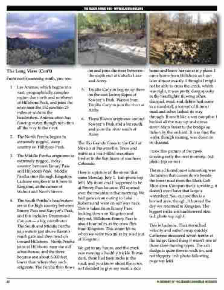
Here is a picture of the storm that came Monday, July 1. (ed: photo top left) My mom and I happened to be at Emory Pass because 152 opened over the mountains that morning. We had gone on an outing to Lake Roberts and were on our way back. This is taken from Emory Pass, looking down on Kingston and beyond, Hillsboro. Emory Pass is about four miles as the crow flies from Kingston. This storm hit us when we were two miles by road out of Kingston.
We got to my house, and the creek was running a healthy trickle. It was dark, there had been rocks in the road, and you know about the cows, so I decided to give my mom a ride
home and leave her car at my place. I came home from Hillsboro an hour later almost exactly. I thought I might not be able to cross the creek, which was right, it was pretty dang spooky in the headlights: flowing ashes, charcoal, mud, and debris had come to a standstill, a torrent of thinner mud and ashes lashed its way through. It smelt like a wet campfire. I backed all the way up and drove down Main Street to the bridge on Italian by the orchard. It was fine; the water, though roaring, was down in its channel.
I took this picture of the creek crossing early the next morning. (ed: photo top center)
The one I found most interesting was the arroyo that comes down beside the forest road from the Black Colt Mine area. Comparatively speaking, it doesn’t even have that large a watershed. You can see this is a burned area, though. It burned the day we returned to Kingston. The biggest rocks are tumbleweed size. (ed: photo top right)
This is Ladrone. That storm had velocity and sailed away quickly. Catherine measured seven-tenths at the lodge. Good thing it wasn’t one of those slow-moving types. The ash sludge is quite firm to walk on, and not slippery. (ed: photo following page top left)
From 1.
north scanning south, you see:
Las Animas, which begins in a vast, geographically complex region due north and northeast of Hillsboro Peak, and joins the river near the 152 junction 25 miles or so from the headwaters. Animas often has flowing water, though not often all the way to the river.
The North Percha begins in extremely rugged, steep country on Hillsboro Peak.
The Middle Percha originates in extremely rugged, rocky country, between Emory Pass and Hillsboro Peak. Middle Percha runs through Kingston. Ladrone empties into it here in Kingston, at the corner of Walnut and North Streets.
The South Percha’s headwaters are in the high country between Emory Pass and Sawyer’s Peak, and this includes Drummond Canyon — a big contributor. The South and Middle Percha join waters just above Bason’s ranch gate and then head on toward Hillsboro. North Percha joins at Hillsboro, near the old schoolhouse, and the three become one about 5,000 feet lower than where they each originate. The Percha then flows
2.
3.
4.
62
iN MEMORY OF THE GRANITE MOUNTAIN HOTSHOTS
