
Page 117 - Land Snails of New Mexico
P. 117
and in the northwest: the San Mateo Mountains, Mt. Taylor (11,200ft),LoboCanyon.Collectionlocalitiesareasindicated in Fig. 1-4, Table 1, and in more detail, in Dillon (1992). Localities are given in continuous numerical sequence for the peaks,asfollows,andwithletterprefixes,asindicated:WB Whitewater Baldy Peak, SB - Sierra Blanca Peak, LP-Lake Peak,MT-MountTaylor.Numbersarearrangedlowestto highest, altitudinally, within canyons.
Whitewater Baldy Transect--The Mogollon Mountains form a northwest-southeast-trending mountain mass approximately 65 k m long and 15 k m wide (Ratté et al., 1979). Physiographically, these mountains are situated within the Datil Mogollon Section, a transitional physiographic subdivision between the Basin and Range and the Colorado Plateau Provinces (Hawley, 1986). The steep southwestern face of the MogollonMountainsiscutbydeepgorgeswithwalls2,500 3,000-ft (ca. 700-915-m) high in places, the canyons of Whitewater Creek and Big Dry Creek being especially precipitous.
The Whitewater Baldy transect (WB), Catron Co., was accessedbyHummingbird SaddleTrail,beginningataheadon NewMexicoStateRoad78,about13kmeastofthetownof Mogollon. Hummingbird Saddle Trail connects to the south at Whitewater Baldy Peak, elevation 10,892 ft(3,320 m), with Whitewater Creek Trail, which descends to the Catwalk Campground 10km northeastofGlenwood,comprising,inall, abackpacktripof>26km.Thetransectdescendsalongthe canyon of Whitewater Creek, which flows westerly to the San FranciscoRiver.Fig.1showsthetopographyoftheWB transect andindicatesLocs.WB-1 to16.
The rocks exposed in the W B transect are nearly all volcanics of Oligocene and Miocene age, associated with the Bursum Cauldron (Ratté et al., 1979). They are ash-flow tuffs and lava flows composed of various igneous rock types such as latites, andesites, a n d rhyolites.
According to Bailey (1913), the central peaks of the Mogollon Mountains, at 11,000 ft (3,353 m), are not high enough to reach true timberline or provide habitat for many Hudsonian Life Zone species. The Canadian Zone covers most of the higher ridges and peaks, forming thick forests of spruce, firs, aspen, and dense understory shrubs, which are "purely Rocky Mountain species" (Bailey, 1913:63). The Transition Zone occurs over large areas from about 6,500ft to 8,500ft on colder slopes and from 8,000 to 9,500 ft on warmer slopes. Upper Sonoran Life Zone tree species such as sycamore, box elder, and lance-leaf cottonwood are found along the canyon at thelowerstations.Pinyonandjuniperarelesscommon alongthe canyon floor than along the more xeric, adjoining walls.
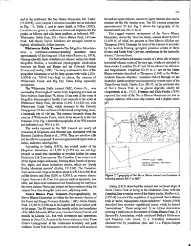
Sierra Blanca Peak Transect-Physiographically, the SierraBlancaMountainsliewithintheSacramentoSectionof
the Basin and Range Province (Hawley, 1986). Sierra Blanca
Peak, 12,003 ft(3,658 m), isthe highest and most salientpeak
intherange.The SB transectliesmostlywithintheboundaries
of the White Mountain Wilderness, Lincoln National Forest, and
mainly in Lincoln Co., but with lowermost and uppermost stationsinOteroCo.AccesstothelowerstationsisfromThree
Rivers Campground at the wilderness boundary and pack trailhead.ForestTrail44ascendstothecresttrailwithaccessto
the mid and upper stations. Access to upper stations also can be
reachedviatheSkiApachearea.TheSB transectcomprises
approximately 20 km. Fig. 2 shows the topography of the transectandLocs.SB-17to37.
The ruggedwesternescarpmentoftheSierraBlanca
Mountains, above the Tularosa Basin, creates about 8,400 ft
(2,560m)ofrelief,thegreatestinNewMexico(Kelleyand
Thompson, 1964).Drainageformostofthetransectisprovided
by the westerly flowing, springfed, perennial creeks of Three
Rivers and South Fork Canyons, terminating in the internally drained Tularosa Basin.
The SierraBlancaMountainsconsistofa thickpileofnearly
horizontalvolcanicrocksofTertiaryage,which areintrudedby three stocks. Localities SB-17 and 18 are situated on alluvium
and fanglomerate. Localities SB-19 to 21 are on the Sierra Blanca volcanics described by Thompson (1964) as the Walker Andesite Breccia Member. Localities SM-22 through 36 are located on syenite porphyry and equigranular syenite units of the Three Rivers Stock. Finally, Loc. SB-37, on the northeast side of Sierra Blanca Peak, is on glacial deposits, chiefly till (Segerstrom et al., 1979). Freeman and Dick-Peddie (1970) reportedthatsoilsoftheSierraBlancaMountainsarelowin organic material, with a low clay content, and a slightly acidic pH.
*.9 S ^ ''
kilometBRs = = " — -
CONTOUR INTERVAL 250 meters 250m=(820ft)
Figure 2.Topography of the Sierra Blanca transect and locations of collectingstationsSB17 toSB37.
Bailey (1913) described the summit and northeast slope of Sierra Blanca Peak as being in the Hudsonian Zone, with the Canadian Zone covering most of the higher peaks. Findley et al. (1975:4)describedthevegetationofuppermostSierraBlanca Peakas"relict,depauperateAlpinemeadows." Martin(1964) described four montane vegetational zones, which he termed "associations." These comprised: 1) an Alpine Association covering a small area on the summit of Sierra Blanca Peak, 2) a Spruce-Fir Association, which combined Bailey's Hudsonian and Canadian Life Zones, 3) a Transition Association
characterized by ponderosa pine, and 4) a Pinyon-Juniper Association.
1RAL_
&
£
*** camparound&
>
g §-
s
:
111
? *
