
Page 118 - Land Snails of New Mexico
P. 118
112
20003"><
*śson, “. \'grube
Chupadero #: n
Medio
VJ
santage(.42 Baldy
'. ( {#1480N
floristiczonesintherange: 1)alpinetundra, 12,000-13,000ft, 2) spruce-fir woodland, 9,000-12,000 ft; 3) mixed conifer woodland, 7,500-9,000 ft, and 4) pinyon-juniper woodland, 6,000-7,500 ft.
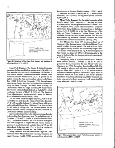
M o u n t Taylor Transect—The San Mateo Mountains, which include Mount Taylor, comprise a 71-km-long northeast southwest trending volcanic plateau northeast of Grants, Cibola Co. (Ungnade, 1972). Mount Taylor formed as a composite stratovolcanoduringthePliocene. Itssummit risestothehighest point, 11,301 ft (3,445 m), in the N e w Mexico part of the Colorado Plateau Physiographic Province. Mount Taylor lies within the Acoma-Zuñi Section of the province. This section is characterized by extensive Cenozoic volcanics that cover erosional and constructional landforms (Hawley, 1986).
New Mexico State Road 547, heading northeast out of Grants, provides the main access to the Cibola National Forest and alllocalitiesalong the transect. The peak ofMount Taylor and upper collecting localities are accessed only by pack trail. The transect covers almost 15 km. Fig. 4 shows topography of this transect and Locs. M T - 5 4 to 67. M a x i m u m relief in this
range is the least of the four transects surveyed, spanning only 4 , 5 7 5 ft ( 1 , 3 9 4 m ) .
Geologically, units of primarily volcanic rocks surround most transect localities. Locations MT-65 to -67 are on
porphyritic flows, which form the main Mount Taylor cone ( L i p m a n e t al., 1 9 7 9 ) . T h e s u r f a c e d e p o s i t s o f L o c s . M T - 5 5 t o -64 consist of alluvium and colluvium, including landslide deposits(Hunt, 1937,Lipman etal.,1979). Some Cretaceous sedimentaryrocksareexposedinlowerLobo Canyon,wherean erosional surface just to the south of Loc, M T - 5 4 truncates folded beds of sandstone and shale (Hunt, 1938). This small area is the only one in the four transects surveyed, herein, in which some sedimentary bedrock occurs.
Kilow'ETERs' + * = =
CONTOUR INTERVAL 250 meters 250m=(820ft)
Figure 3.Topography of the Lake Peak transect and locations of collectingstationsLP38 toLP53.
Lake Peak Transect--The Sangre de Cristo Mountains encompassthelargestandhighestmontane areainNew Mexico. Theycompriseanorth-to-southorientedrange,160km longin N e w Mexico, from the Colorado border to near Santa Fe. These mountains include Wheeler Peak, 13,161 ft (4,011 m), the highest point in the state, and more than a dozen peaks higher than 12,000 ft (3,658 m) (Ungnade, 1972). Several ranges comprise the Sangre de Cristo Mountains--the southernmost being the Santa Fe Range. Lake Peak, Santa Fe Baldy, and Capulin Peak, within this range, exceed 12,000 ftin elevation. This transect culminated on Lake Peak, in Santa Fe Co., which reachesanelevationof12,409ft(3,782m).TheSangrede Cristo Mountains are, physiographically, within the Southern Rocky Mountain Province (Hawley, 1986).
T h e four lowest localities along the transect ( L P - 3 8 to 41) are reached by foot trailsfrom the village ofEn Medio. Localities LP-42 to 53 are within the Santa Fe National Forest, with access viaForestRoad102westfromNM State475orfromtheSanta
Fe Ski Basin by hiking trails. The distance covered by this transect exceeds 20 km. Topography of the LP transect and Locations LP-38 to 53 are shown in Fig. 3.
Igneous and metamorphic rocks of Proterozoic age form the bedrock of the Lake Peak study area. The surficial deposits at Locations LP-38 and 39 consist of gravelly alluvium (Hunt, 1977).LocalitiesLP-40and41 and47to50lieoninterlayered rock units comprised of amphibolite and various classes of gneisses.A quartzdioriteunitunderliesLocs.LP-43and44. Mappedunitsfortheuppersites,LP-51 to53,showinterlayered gneiss of two species (Moench and Lane, 1988).
Bailey described five life zones in the Sangre de Cristo Mountains: Arctic-Alpine, Hudsonian, Canadian, Transition, and Upper Sonoran. Knight (1990) recognized four elevational
108" 104"
** ***==
CONTOUR INTERVAL 250 meters 250m=(820ft)
Figure 4.Topography of the Mount Taylor transect and locations of collectingstationsMT54 toMT67.
