
Page 236 - STG19
P. 236
National Parks
1–Zion National Park
435 772-3256
www.nps.gov/zion/
Springdale
Visitor Center
888 518-7070
www.zionpark.com
Zion is an ancient Hebrew word meaning a place of refuge or sanctuary. Protected within the
park’s 229 square miles is a dramatic landscape of sculptured canyons
and soaring cliffs. Zion is located at the junction of the Colorado Plateau, Great Basin, and Mojave Desert provinces. This unique geography and the variety of life zones within the park, make Zion significant as a place of unusual plant and animal diversity. It is 43 miles northeast of St. George. Take I-15 north to the Hurricane exit (Exit 16) and go east to Hurricane on S.R. 9 and follow the signs. Please see their website for more information and park fees.
Private vehicles are not allowed on the Zion Canyon Scenic Drive, but there is a shuttle in operation that will provide a stress free access into the park. Highway 9 through the Park is open to private vehicles year-round, connecting Springdale to Bryce Canyon, the North Rim of the Grand Canyon, and Kanab. The Visitor Center has information on shuttle operation, weather conditions, back country permits, and reservations for the lodge, maps, and other publications.
2–Kolob Canyon
435 586-9548
www.nps.gov/zion
I-15 Exit #40
3752 E Kolob Canyons Rd, New Harmony
Kolob Canyon is located along the western edge of Zion National
Park. Kolob was made a National Monument in 1937 and incorporated into Zion in 1956. It is about 35 miles north of St. George on I-15 take Exit 40. A five mile scenic drive climbs past the towering red cliffs of the Kolob finger canyons and provides access
to 3 maintained trails and views of wildlife. Please see the website for more details and park fees. Open all year. The Visitors Center is open every day except major holidays.
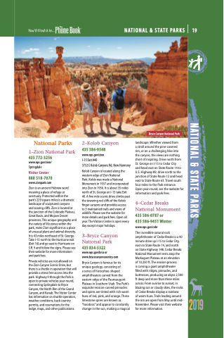
3–Bryce Canyon
National Park
435 834-5322
www.nps.gov/brca or www.brycecanyoncountry.com
Bryce Canyon is famous for its unique geology, consisting of
a series of horseshoe-shaped amphitheaters carved from the eastern edge of the Paunsaugunt Plateau in Southern Utah. The Park’s exquisite erosion-carved pinnacles and spires are tinted with rich warm hues of red, pink, and orange. These limestone spires are known as “hoodoos” and appear to constantly change in the sun, making a magical
Bryce Canyon National Park
landscape. Whether viewed from
a stroll around the pine-covered
rim, or on a challenging hike into the canyon, the views are nothing short of inspiring. Drive north from St. George on I-15 to Cedar City
and head east on State Route 14 to U.S. Highway 89, drive north to the junction of State Route 12 and head east to State Route 63. Travel south four miles to the Park entrance. Open year-round, see the website for information and park fees.
4–Cedar Breaks National Monument 435 586-0787 or
435 586-9451 Winter
www.nps.gov/cebr
The incredible natural rock amphitheater of Cedar Breaks is a 90 minute drive up I-15 to Cedar City, east on State Route 14, and north
on State Highway 148. Cedar Breaks National Monument rests atop the Markagunt Plateau at an elevation of 10,350 ft. The erosion process
is carving a giant amphitheater
filled with ridges, pinnacles, and buttresses, producing an abyss 2,500 ft deep and more than three miles across. From sunrise to sunset, in blazing sun or cloudy skies, the rocks of Cedar Breaks display a rainbow
of warm hues. Trails leading around the rim are open from May until mid- November. Please visit their website for more information.
2019
NATIONAL & STATE PARKS 19
NATIONAL & STATE PARKS
