
Page 24 - Ranger Demo
P. 24
sites convenient for access as practicable. In some places small trenches were excavated, to afford easy channels for, conveying the water to the terraces. These tanks were for domestic uses. Attached to them were larger ones for washing purposes, which were filled by the surplus water from the drinking reservoirs through the agency of small troughs, fixed near the top of the partitional embankments. Where springs could not be found in sufficient numbers, wells were sunk to afford water for the troops...In several instances the men were interrupted in the service by the presence of moving quicksand' s...To keep the ground from being undermined by the sand, rough sap rollers were at first constructed and sunk, but as there were found inadequate to meet the difficulty, on account of the sand oozing through the interstices of the brushwood some barrels were securely fixed at the bottom, which at once offered an effectual resistance of good clean water. Into several of the wells, two or three bushels of pebbles and shells were thrown to purify the water in its infiltration...Two artesian wells were also bored late in July, one to a depth of sixty feet and the other to thirty-five feet...13
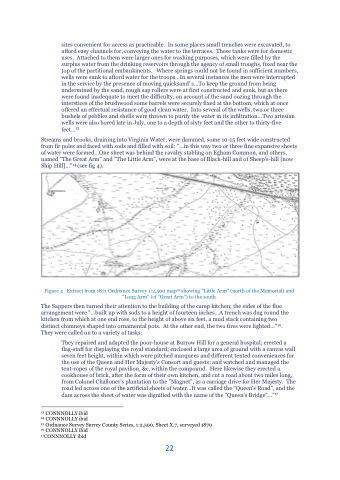
Streams and brooks, draining into Virginia Water, were dammed, some 10-15 feet wide constructed from fir poles and faced with sods and filled with soil: "...in this way two or three fine expansive sheets of water were formed...One sheet was behind the cavalry stabling on Egham Common, and others, named "The Great Arm" and "The Little Arm", were at the base of Black-hill and of Sheep's-hill [now Ship Hill]..."14 (see fig 4).
Figure 4 Extract from 1871 Ordnance Survey 1:2,500 map15 showing "Little Arm" (north of the Memorial) and "Long Arm" (cf "Great Arm") to the south
The Sappers then turned their attention to the building of the camp kitchen; the sides of the flue arrangement were "...built up with sods to a height of fourteen inches...A trench was dug round the kitchen from which at one end rose, to the height of above six feet, a mud stack containing two distinct chimneys shaped into ornamental pots. At the other end, the two fires were lighted..."16. They were called on to a variety of tasks:
They repaired and adapted the poor-house at Burrow Hill for a general hospital; erected a flag-staff for displaying the royal standard; enclosed a large area of ground with a canvas wall seven feet height, within which were pitched marquees and different tented conveniences for the use of the Queen and Her Majesty's Consort and guests; and watched and managed the tent-ropes of the royal pavilion, &c, within the compound. Here likewise they erected a cookhouse of brick, after the form of their own kitchen, and cut a road about two miles long, from Colonel Challoner's plantation to the "Magnet", as a carriage drive for Her Majesty. The road led across one of the artificial sheets of water...It was called the "Queen's Road", and the dam across the sheet of water was dignified with the name of the "Queen’s Bridge”...”17
13 CONNNOLLY ibid
14 CONNNOLLY ibid
15 Ordnance Survey Surrey County Series, 1:2,500, Sheet X.7, surveyed 1870 16 CONNNOLLY ibid
17CONNNOLLY ibid
22
