
Page 63 - combinepdf
P. 63
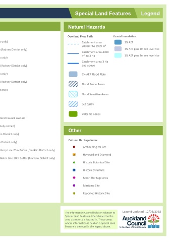
Legend        1% AEP  1% AEP plus 1m sea level rise  1% AEP plus 2m sea level rise                Legend updated: 12/06/2018


        Special Land Features  Natural Hazards  Coastal Inundation Overland Flow Path  Catchment area  2000m² to 3999 m²  Catchment area 4000  m² to 3 Ha  Catchment area 3 Ha  and above  1% AEP Flood Plain  Flood Prone Areas  Flood Sensitive Areas  Sea Spray  Volcanic Cones  Other  Cultural Heritage Index  Archaeological Site  Y  "  Hayward and Diamond  /  "  Historic Botanical Site  #  Z  Historic Structure  "  J  Maori Heritage Area  .  !  Maritime Site  !  >  $  K Repo


               Hazards  Soil Warning Area continued  Soil D (Rodney District only) within 150m of Soil D (Rodney District only)  Soil C (Rodney District only) within 150m of Soil C (Rodney District only)  Soil B (Rodney District only) within 150m of Soil B (Rodney District only)  Soil A (Rodney District only)  Gas Main Pipeline  Petroleum Pipeline Closed Landfill (Auckland Council owned)  Closed Landfill (Privately owned)  Air Discharge (Franklin District only)  No Soakag


        Auckland Council  Hazards  Soil Warning Area  Fill (Franklin District only)  Advisory (Franklin District only)  Contamination (Franklin District only)  Erosion (Franklin District only) Hazardous Activities & Industries List (HAIL) (Franklin District only)  Inundation (Franklin District only)  Rainfall Event (Franklin District only)  Slippage (Franklin District only)  Subsidence (Franklin District only) Slippage / Subsidence / Erosion etc (Auckland City and Papakur