
Page 26 - ShareSpace's Mars Map Teacher's Guide - Sept 2016
P. 26
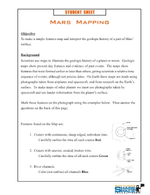
STUDENT SHEET

           Mars Mapping

Objective
To make a simple features map and interpret the geologic history of a part of Mars’
surface.

Background
Scientists use maps to illustrate the geologic history of a planet or moon. Geologic
maps show present day features and evidence of past events. The maps show
features that were formed earlier or later than others, giving scientists a relative time
sequence of events, although not precise dates. On Earth these maps are made using
photographs taken from airplanes and spacecraft, and from research on the Earth’s
surface. To make maps of other planets we must use photographs taken by
spacecraft and use lander information from the planet’s surface.

Mark these features on the photograph using the examples below. Then answer the
questions on the back of this page.

Features found on the Map are:                                       ejecta
                                                                       floor and sides
       1. Craters with continuous, sharp-edged, unbroken rims.         of crater
               Carefully outline the rims all such craters Red.
                                                                          crater rim
       2. Craters with uneven, eroded, broken rims.
               Carefully outline the rims of all such craters Green  eroded
                                                                     crater rim
       3. River channels.
               Color (not outline) all channels Blue.                   crater
                                                                        floor
                                                                        outer crater
                                                                        slope

                                                                      flow
                                                                      channels