
Page 53 - 2006 DT 12 Issues
P. 53
Mummy’s Nose with Peppe. Stren. 6 mi. abundant plant life and stop at Barrier Rock, down at Cathedral Rock, the Echo
Sat. 15, “Astronomy” - This program where we’ll have a snack before heading subdivision and the Lodge at Mount
is for everyone young and mature. LVAS will back. Mod. 4 mi. Charleston. This is a good place to rest.
have telescopes for sharing and present a The elevation is approximately 9,100 ft.
slide program. Gate will close at 8:30 PM. From here there’s another 2 miles to go
There will be NO admittance after 8:30 PM! and an elevation gain of 1,500 ft. Oh yes,
Sun. 16, “Big Falls” - This is one of The Switchback one reminder—the switchbacks go on
the most spectacular waterfalls in the Spring at the End of the Galaxy and on. Just when you think you’ve got-
Mtns, per George. We’ll hike through Pon- by Norm Kresge ten to the last switchback, you haven’t.
derosa pines and aspens, cross a creek a few There are more!
times with some bouldering. Mod/Stren. 4 mi. t’s 100 degrees in Las Vegas and Near the junction where the trail
Mon. 17, “Pine Creek” - Hike this just too hot to hike at Red Rock. splits at the crest of the mountain—one
beautiful trail with Janis and enjoy the Pon- IAn alternative is to head to Mount to Griffith Peak, the other to Charles-
derosa pines and visit the remains of the old Charleston. If you want to do a strenu- ton Peak—the trees begin to thin, a
homestead. Mod. 3 mi. ous hike, enjoy the fresh air, smell meadow starts and it’s common to
Wed. 19, “Mt. Charleston” - Join Chris some wonderful pine and enjoy stun- see chipmunks scampering in search
and climb the highest peak in the area on this ning vistas, the hike to Griffith Peak is of food. Resist the urge to feed them.
full day adventure with an elevation gain of a must. The trek is 9 miles round trip They need to forage for food and not
4,300 ft. Very strenuous, 17 mi. (not including the walk to and from the become dependent on people. When
Fri. 21, “Bridge Mtn.” - Get out and get parking area) with an elevation gain of you reach the intersection of the trails,
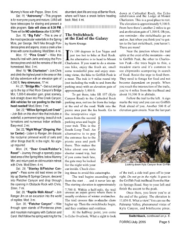
up to the top of Red Rock Canyon’s Bridge approximately 3,400 ft. you’re 4 miles from the trailhead and
Mtn; 1,000-ft elevation gain, great scenery, To get there, take SR 157 (Kyle about 10,500 ft in altitude.
look straight down into Pine Creek Canyon; Canyon Road) to the Cathedral Rock Follow the trail to the left. A sign
4X4 vehicles for car pooling to the trail- parking area, not too far from the lodge marks the way and you can see Griffith
head needed! Mod./Stren. 7 mi; at the end of the road. Walk into the Peak ahead of you. Another 500 ft of
Sat. 22, “Willow Springs/Lost Creek” picnic area past the fee booth. Go to elevation gain awaits. Near the last part
- Join Bob on this short hike that includes a the interpretive sign
waterfall, a permanent spring, beautiful rock across from the second
formations and numerous Indian artifacts. parking area and begin
Easy-mod. 2 mi. your trek. This is the
Sat. 22, “Night Wings” (Ongoing, Visi- South Loop Trail. An ©Courtesy Norm Kresge
tor Center) - Listen to Ranger Jim discuss alternative is to pay
the nocturnal primeval world of owls and the entrance fee to the
other things that flit in the night. No sign- picnic area and park
up required. there. This makes the
Mon. 24, “Deer Creek/Robber’s hike about one mile
Roost” - Journey through a sparsely popu- shorter round trip, but
lated area of the Spring Mtns. below Mummy if you come back late,
Mtn. and return past an old mountain retreat the gate may be locked
with Chris. Mod/Stren. 4 mi. for the night with your Looking down Kyle Canyon from Griffith
Sat. 29, ”Stanley B/Fletcher Can- car inside. Check clos-
yons” - Pass some old lead mines on the ing times to avoid this catastrophe. of the trail, a side trail goes off to your
trip up Stanley B Springs Canyon, descend The trail begins ascending right right. Do not go to the right. It goes to
into Fletcher Canyon and drop through from the start . . . and it never lets up. the Griffith Peak trailhead from the Har-
the opening in Obstacle Rock with Chris. The starting elevation is approximately ris Springs Road. Stay to your left and
Stren. 7 mi. 7,700 ft. Within a half-mile, the trail finish the ascent to the peak.
Sat. 29, “Reptile Walk About” - Join crosses an aspen grove where there is Once there, you know you’re at
Ranger Jim on an excursion into the world usually evidence of winter avalanches. the end of the galaxy. The elevation is
of reptiles. Mod. 3 mi. The trail crosses this avalanche chute 11,056 ft. What a view! You can see the
Sun. 30, “Fletcher Canyon” - Hike higher up. Then the switchbacks begin, Pahrump Valley, phenomenal vistas of
through open stands of Ponderosa pines and they continue and continue. Kyle Canyon, and bristlecone pines.
and mountain mahogany with Carleton and At the halfway point, you come
Carol. We’ll follow the spring watching for the to Echo Overlook. What a sight to look Switchback, continued on p. 6.
FORRC/July 2006 Page 5