
Page 18 - Spring 2020 MT_v5.indd
P. 18
TRAIL history ssissippi River
ip
p
ipp
The Ice Age Complex at Cross Plains: Layers of
History, Layers of Teamwork
WRITTEN AS A COLLABORATIVE EFFORT AMONG NPS AND IATA STAFF AND VOLUNTEERS
Two curving, half-moon shaped boardwalks examples of glaciation in Wisconsin. You
and a 48-foot bridge spanning a small ravine might recognize a few of them: Interstate
stirred up quite a bit of excitement after they Park in Polk County, Devil’s Lake State
were built during a June 2019 Mobile Skills Park in Sauk County, and the Kettle
Crew event. As the sawdust settled, and the Moraine State Forest. The nucleus of the
fi nal kick rail was secured into place, what Cross Plains Unit of the Ice Age National
emerged was the exclamation point on the Scientifi c Reserve is another of them.
nine-mile Cross Plains Segment. This 1.5-mile Then, the Ice Age Trail earned its offi cial
section of Ice Age National Scenic Trail, along designation as one of eleven National
with its .4-mile white-blazed loop, highlights Scenic Trails in 1980 as part of the
what was once the lake bed of a proglacial lake National Trails System Act, also created
which formed in the face of melting glaciers. by Congress. For a long time, the Ice Age
This nine-mile segment, which wends its way National Scenic Trail, as it wended its
across the Cross Plains township, beginning at way through the state, connected fi ve of
Hickory Hill Street in the village of Cross Plains the nine reserve units, except for the one
and ending on Timber Lane at the edge of nearest the second largest population
the city of Madison, highlights the edge of the center in Wisconsin, the Cross Plains Unit
terminal moraine. Along the way, it showcases of the Ice Age Reserve.
where the Laurentide ice sheet ground to a In 1975, the DNR purchased the fi rst
halt, marking the eastern boundary of the 100 acres within what was outlined as
Driftless area. The ghosts of the glaciers are potential boundary lines for the Cross
exceedingly present in the rushing, melting Plains unit. A 60-acre purchase followed,
water which carved the post-glacial streambed but the next purchase followed much,
of the Black Earth Creek Valley. They haunt the
weathered dolomite bedrock jutting from the
valley walls in massive formations.
The geologically signifi cant landscape
features found within the Cross Plains area
are what brought several public entities
together in partnership to preserve this
important glacial history. When you hike
the southernmost mile of the Cross Plains
Segment, you access parcels of land
comprising an Ice Age National Scientifi c
Reserve unit, now referred to by the National
Park Service (NPS) and other partners, as
the Ice Age Complex at Cross Plains.
The idea, already percolating in the 1950s,
was to establish a hiking trail through
Wisconsin, which would follow the entire length
of the moraines marking the edge of the last
glacier. With a little more effort by visionaries,
Congress, in 1964, approved creating nine Ice
Age National Scientifi c Reserve units.
These nine Ice Age Reserve units,
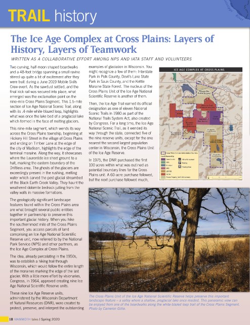
administered by the Wisconsin Department The Cross Plains Unit of the Ice Age National Scientifi c Reserve helps preserve this important
landscape feature – a valley where a shallow, proglacial lake once resided. This panoramic view can
of Natural Resources (DNR), were created to be enjoyed from one of the boardwalks along the white-blazed loop trail of the Cross Plains Segment.
protect, preserve, and interpret the outstanding Photo by Cameron Gillie.
18 MAMMOTH tales | Spring 2020