
Page 479 - Kosovo Metohija Heritage
P. 479
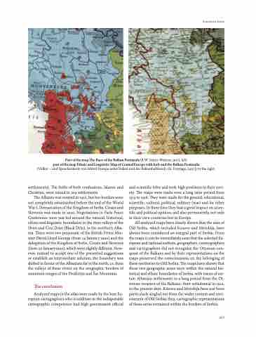
 Part of the map The Race of the Balkan Peninsula (R.W. Seton-Watson, 1917), left;
part of the map Ethnic and Linguistic Map of Central Europe with Italy and the Balkan Peninsula
(Völker – und Sprachenkarte von Mittel-europa nebst italien und der Balkanhalbinsel), (G. Freytags, [1917]) to the right.
settlements). The Serbs of both confessions, islamic and Christian, were mixed in 109 settlements.
The albania was created in 1912, but her borders were not completely estanluished before the end of the World War i. Demarcation of the Kingdom of Serbs, Croats and Slovenes was made in 1920. Negotiations in Paris Peace Conference were just led around the natural, historical, ethnic and linguistic boundaries in the river valleys of the Drim and Crni Drim (Black Drin), in the northern alba- nia. There were two proposals: of the British Prime Min- ister David Lloyd George (from 14 january 1920) and the delegation of the Kingdom of Serbs, Croats and Slovenes (from 20 january1920), which were slightly different. How- ever, instead to accept one of the presented suggestions or establish an intermediate solution, the boundary was shifted in favour of the albanians far in the north, i.e. from the valleys of these rivers on the orographic borders of mountain ranges of the Prokletije and Šar Mountain.
The conclusion
analyzed maps in the atlas were made by the best eu- ropean cartographers who in addition to the indisputable cartographic competence had high government official
and scientific titles and took high positions in their soci- ety. The maps were made over a long time period from 1513 to 1918. They were made for the general, educational, scientific, cultural, political, military (war) and for other purposes. in their time they had a great impact on scien- tific and political opinion, and also permanently, not only in their own countries but in europe.
all analyzed maps have clearly shown that the area of Old Serbia, which included Kosovo and Metohija, have always been considered an integral part of Serbia. From the maps it can be immediately seen that the selected eu- ropean and national authors, geographers, cosmographers and cartographers did not recognize the Ottoman con- quest of the Balkans and by their representations on the maps preserved the consciousness on the belonging of these territories to Old Serbia. The maps have shown that these two geographic areas were within the natural his- torical and ethnic boundaries of Serbia, with traces of cer- tain albanian settlements in a long period from the Ot- toman invasion of the Balkans, their withdrawal in 1912, to the present days. Kosovo and Metohija have not been particularly singled out from the wider context and envi- ronment of Old Serbia; thus, cartographic representations of these areas remained within the borders of Serbia.
european Maps
  477
