
Page 480 - Kosovo Metohija Heritage
P. 480
Mirčeta Vemić
Most of the maps confirm that the main division bor- der, i.e. ethnographic boundary between Serbian and al- banian settlements, until the mid-19th century, was on the rivers Valbona (Crnica), Drim (Drin) and Crni Drim (Black Drin), which were regarded as both geographical border of albania and (Old) Serbia, as well as a language line di- viding the albanians of northern albania from the Me- tohija Serbs. in this sense, with the creation of albania 1912, a historic compromise regarding the demarcation of the state borders between Serbia and albania went from the mentioned rivers to the highest peaks of the moun- tain range.
References
Beilage No 3. (1899). Political division, nationalities and religions (Polit Eintheilung, Nationalitäten und Religionen), 1:750 000 Beilage No 3. zur Detailbeschreibung des Sandžaks Plevlje und des Vilajets Kosovo (Mit 8 Beilagen und 10 Tafeln.) als Manuscript gedruckt. Wien.
Blaeu, i. [1662–1665]. Today’s Illyricum,... (Illyricvm Hodi- ernvm, Quod Scriptores communiter Sclavoniam, Itali Schi- avoniam nuncupare solent, in Dalmatiam, Croatiam, Bos-
niam, et Slavoniam distinguitur Sed cum ejus majorem par- tem Turcæ optineant in Præfecturas eorum more Sanzaca- tus dictas divisum est, reliquum autem Veneti, Vngari, et Ra- gusini tenent Sanzacatus sunt Bosna, Residentia Baßæ; Pox- ega; Cernik; Bihak; Lika et Carbava; Clissa; Herzegowina), [1:915 000] [amstelaedami].
Boehmio, a.G. (1766). The latest map of the Danube with the surrounding kingdoms, as well as whole Greece and the archipelago (Totius Danubii cum Adjacentibus Regnis nec non Totius Græciæ et Archipelagi), [1:44 000 000] Norimbergae.
Bošković, P. S. (1914). New Map of the Serbian Kingdoms and Neighboring Areas, 1:1 000 000. Belgrade: Kartografska radionica Geografskog odeljenja Gl. Dj-štaba.
Vasojević, N. [1847]. Map of Kosovo Polje (Situations-Plan von Kosowo-Polje, Amselfeld), 1:200 000 [Novi Sad]: Pečat Loler.
Vemić, M. (2005). An ethnic map of a part of Old Ser- bia Based on the travelogue of Miloš S Milojević 1871–1877 Belgrade: Geografical institute „jovan Cvijić“ Serbian acad- emy of Sciences and arts, Monographs, vol. 61.
Vemić, M. (2011). Serbs in Kosovo and Metohija in the Second Half of the 19th Century according to an ethnic Map
478
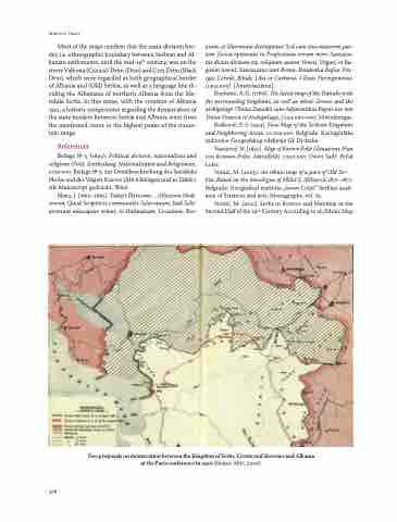
Two proposals on demarcation between the Kingdom of Serbs, Croats and Slovenes and Albania at the Paris conference in 1920 (Slukan-altić, 2006)
