
Page 2 - Student Edition Week 20
P. 2
Technology of Exploration Spanish Colonization Week 20 of 32 • Page 3
There were many tools that made European exploration possible. measurements to a table of latitudes that told
measurements to a table of latitudes that told
Funds, like those that Prince Henry the Navigator provided, were vital them where they were. The first Spanish colonists were mostly Bartolomé de las Casas lived on Hispañola being when the Spanish misunderstood a
to exploration. The caravel, a smaller, faster sailing ship, also made men. They came to the colonies to be during the first wave of colonization. He Quechua word.
traveling on the open ocean possible. However, other tools were Sextant conquistadors, hoping to gain land and estimated that 80–90 percent of the Taíno During much of the Spanish colonial
crucial to the Age of Exploration. Sextants, like astrolabes, measure angles wealth through conquest. The first Spanish people died within the first 50 years of period, only men migrated to the
to determine the latitude of a ship. settlements were on an island that Spanish colonization. Americas. They often had relationships
Cartographic Improvements However, they also measure longitude. Columbus named Hispañola. This Island is Early Spanish colonization focused with and married native women. Because
Accurate maps were not very common in the Middle Ages. Prior They measure the distance between the located in the Caribbean and is the home on the areas of major conquest: the of these relationships, the population of
to the invention of the printing press, all maps were hand-drawn, horizon and a celestial body, such as the of the modern-day countries of Haiti and Caribbean, the Aztec Empire, and the Inca the Spanish colonies grew to be
which made them very difficult to create. During the Renaissance, sun or moon. That measurement is matched Sextant the Dominican Republic. The native people mostly people of mixed Spanish and
sun or moon. That measurement is matched
cartography took on new importance. The Greek scholar Ptolemy with the measurements on a table, which identifies from the island were called the Taíno, and Empire. The Caribbean islands that were Indigenous heritage.
es
with the measurements on a table, which identifi
studied cartography and developed a grid with lines called latitude a location’s latitude and longitude. Knowing both longitude and they called their island home Quisqueya. conquered by the Spanish were often The Spanish colonies eventually
and longitude. These could be used to help travelers determine their latitude gave explorers an exact location. Sextants are still used by Because the Taíno were the first called the West Indies because Columbus extended into Florida and the
exact location on the globe. Latitude and longitude lines were tools sailors today. Native Peoples to have Europeans live in mistakenly thought he had reached islands southwestern portion of the modern-day
used by Renaissance-era cartographers to create better maps. on the outskirts of India. The former
As European explorers traveled to new areas of the world, they Compass constant, close proximity, they suffered Aztec Empire was called “New Spain” by United States. Spanish colonies also spread
made maps to chronicle where they had been, stake claims for their One of the earliest navigational tools was the magnetic compass. It terribly from the diseases that the Spanish throughout all of Central America and
governments, and help others travel back to these destinations. was first invented in China over 1,000 years ago. Europeans learned brought. The first Spanish colonists also the Spanish conquistadors. “Peru” was everywhere in South America, except for
In 1569, Gerardus Mercator innovated cartography even further about the compass from the Arabs, who had originally learned of forced the Taíno people to work for them the name the Spanish gave the Inca Brazil. The Portuguese claimed Brazil as
by creating a map that flattened out the globe. The longitude and this invention from the Chinese in about 1000 or 1100 C.E. To use in the encomienda system. Spanish writer Empire. This name most likely came into their own colony.
latitude lines on these maps were straight. This flat map was a tool the first compasses, sailors rubbed an iron needle on a rock called
that allowed sailors to plot their destinations on fixed lines. It made a lodestone. The needle then became magnetized. The needle was
traveling across oceans easier. then stuck into a piece of straw or something else that would float
and placed in a cup of water. The needle would always point north.
Astrolabe The compass did not pinpoint location, but it helped sailors know Portrait of
For hundreds of years, people have looked at objects in the night sky which direction they were traveling. Bartolomé de
to help keep track of where they were. Looking at the night sky Las Casas
and knowing where the stars are helps a person on the ground
know which direction to travel. For example, the North Star will
tell you which direction is north, no matter where you are. Once
explorers know which way is north, they can use other scientific
tools to pinpoint their location, chart their courses, and sail all
the way around the world.
One of the most important tools navigators used during the
Age of Exploration was the astrolabe. Sailors used astrolabes to
travel across wide-open seas by measuring the latitude of a ship
at sea. Using the sun during the day and the North Star at night,
sailors would point the indicator on the astrolabe at their chosen
celestial object (the sun or the North Star). Then, they would
read the dial to determine their latitude. They compared their
Taíno farmers
Mariner’s Astrolabe
Compass
English Colonization Portuguese Colonization
oloniz
ation
P
or
tuguese C
English colonization allowed English citizens to start new lives across the to practice. This freedom was included in The Portuguese had a great empire that they started building in
sea. Some colonists were motivated to make money and gain a higher the charter. the 1420s. They created trade centers from West Africa, around
status in society. Other colonists came to practice their religion freely Another form of charter created a the Cape of Good Hope, to Asia and into South America. This
and avoid persecution. Many others sought the chance to get land of their proprietorship. In this case, the king gave a allowed them to become one of the first intercontinental empires
own, which was very difficult in Europe. Regardless of the motivations charter to a person as a reward for services when they were able to create Portuguese Brazil.
behind their decisions, all colonists came as a result of a charter. to the king. The person given the charter Vasco da Gama was the third son of a minor nobleman in
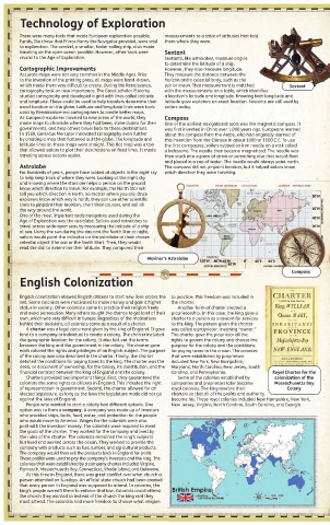
A charter was a legal document given by the king of England. It gave was called a proprietor, meaning “owner.” Portugal. In 1492, he earned a name for himself by seizing French
land to a company or individual to create a colony. The charter included The charter gave the proprietor all the vessels that had violated Portuguese shipping rights. After this
the geographic location for the colony. It also laid out the terms rights to govern the colony and choose the success, the king chose da Gama to lead an expedition to East
between the king and the government in the colony. The charter gave purpose for the colony and the conditions Asia to set up trade between Portugal and Asia.
each colonist the rights and privileges of an English subject. The purpose for paying taxes to the crown. The colonies In July 1497, da Gama set out with four ships. By January 1498,
of the colony was also described in the charter. Finally, the charter that were established by proprietors they had reached Mozambique, an island off of the eastern coast
detailed the conditions for paying taxes to the king. The charter was the included New York, New Hampshire, of Africa. The da Gama expedition spent an extended period of
deed, or document of ownership, for the colony, its constitution, and the Maryland, North Carolina, New Jersey, South time there resting and recovering from scurvy. Scurvy is a disease
financial contract between the king of England and the colony. Carolina, and Pennsylvania. Royal Charter for the that sailors often developed from not getting enough vitamin C.
Charters provided two important things. First, they guaranteed the Some of the colonies established by colonization of the Sailors got this disease from not having enough fresh fruits or
colonists the same rights as citizens in England. This included the right companies and proprietors later became Massachusetts Bay vegetables on their ships.
of representation in government. Second, the charter allowed for an royal colonies. The king rewrote their Colony The trade routes, currents, and winds on the eastern side of
elected legislature, as long as the laws the legislature made did not go charters so that all of the profits and authority Africa had been known and traveled for hundreds of years by
against the laws of England. became his. These royal colonies included New Hampshire, New York, Muslim traders. The Portuguese used this knowledge to reach
People who wanted to start a colony had different options. One New Jersey, Virginia, North Carolina, South Carolina, and Georgia. India in May 1498. The expedition had achieved its goal. Da which are so marvelous … that I fancied myself to be
option was to form a company. A company was made up of investors Gama returned to Portugal but later returned to India on two near the terrestrial paradise.
who provided ships, tools, food, water, and protection for the people more voyages. This led to the creation of Portuguese trading Brazil had many natural resources that Portugal
who would move to America. Wages for the colonists were also posts from East Africa all the way to Japan. utilized to create goods and products to send back
paid with the investors’ money. The colonists were required to meet Da Gama’s route around Africa and into Asia played a crucial to Europe for a profit. Brazil became the largest
the goals of the charter. They worked for the company and lived by role in Pedro Álvares Cabral sailing too far west and accidentally sugar producer within a few decades of Portugal
the rules of the charter. The colonists remained the king’s subjects
but lived and worked across the ocean. They worked to provide the finding Brazil. The winds off the coast of Africa blew Cabral off colonizing, or taking over, the area. It started with
company with products such as furs, lumber, and agricultural products. course, and he and his crew landed in Brazil. After this discovery, 60 sugar mills in 1570, and within 75 years, there
The company would then sell the products back in England for profit. an explorer named Gonçalo Coelho led an expedition into were 350 sugar mills. Brazil also had a large timber
These profits were used to pay the company’s investors and the king. The Brazil’s coastline to discover more about the country. The Treaty industry that took advantage of the hardwoods for
colonies that were established by a company charter included Virginia, of Tordesillas gave Portugal their own sphere of influence in Vasco da Gama lumber and the dye that could be produced from
Plymouth, Massachusetts Bay, Connecticut, Rhode Island, and Delaware. Brazil, and they were able to claim it as their own. Florentine the brazilwoods. The hardwoods were used to create
At this time in England, there was great conflict over what church a Amerigo Vespucci also visited Brazil and was amazed by the everything from tables to violins.
person attended on Sundays. An official state church had been created sights he saw. He wrote the following description of what he saw: The colonization of Brazil was similar to that of the English
that every person in England was supposed to attend. In colonies, the This land is very delightful, and covered with an infinite number of settlement in North America. A group of several hundred colonists came
king’s people weren’t there to enforce that law. Colonists could attend green trees and very big ones which never lose their foliage, and through to the coast of Brazil to build different settlements. Portugal set up
the church they wanted to instead of the church the king said they the year yield the sweetest aromatic perfumes and produce an infinite “captaincies.” This gave grants to Portuguese nobles and their workers
must attend. The colonists had more freedom to choose what religion variety of fruit, gratifying to the taste and healthful to the body … and to develop land to farm on. Many other colonists from Portugal moved to
the fields produce herbs and flowers and many sweet and good roots, Brazil in order to practice the religion they chose.