
Page 4 - GS58346 Tasik Chini
P. 4
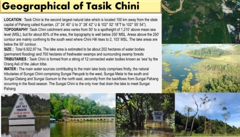
Geographical of Tasik Chini


    LOCATION : Tasik Chini is the second largest natural lake which is located 100 km away from the state
    capital of Pahang called Kuantan. (3° 24’ 40” U to 3° 26’ 42” U & 102° 52’ 18”T to 102° 55’ 54”).

    TOPOGRAPHY :Tasik Chini catchment area varies from 50’ to a spotheight of 1,210’ above mean sea
    level (MSL), but for about 80% of the area, the topography is well below 250’ MSL. Areas above the 250’

    contour are mainly confining to the south west where Chini Hill rises to 2, 103’ MSL. The lake areas are

    below the 50’ contour.
    SIZE :  Total 6,922,97 ha. The lake area is estimated to be about 202 hectares of water bodies

    (permanent flooding) and 700 hectares of freshwater swamps and surrounding swamp forests
    TRIBUTARIES : Tasik Chini is formed from a string of 12 connected water bodies known as 'sea' by the

    Orang Asli of the Jakun tribe.
    WATER : The main water sources contributing to the main lake body comprises firstly, the natural

    tributaries of Sungai Chini comprising Sungai Perupok to the west, Sungai Melai to the south and

    Sungai Datang and Sungai Gumum to the north east, secondly from the backflows from Sungai Pahang
    occurring in the flood season. The Sungai Chini is the only river that drain the lake to meet Sungai
    Pahang