


Page 840 - PPL BEG-engelsk
P. 840
Navigation


                9.6.2    Overview – all together


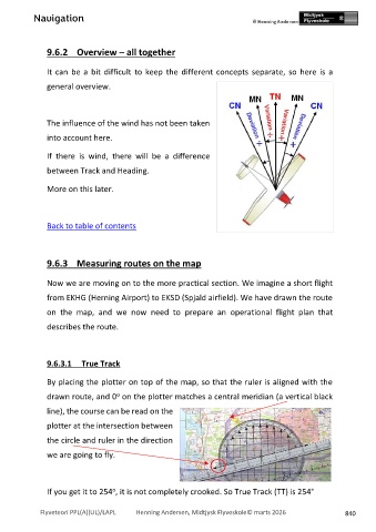
                It  can  be  a  bit  difficult  to  keep  the  different  concepts  separate,  so  here  is  a
                general overview.


                The influence of the wind has not been taken
                into account here.


                If  there  is  wind,  there  will  be  a  difference

                between Track and Heading.


                More on this later.


                Back to table of contents


                9.6.3    Measuring routes on the map


                Now we are moving on to the more practical section. We imagine a short flight

                from EKHG (Herning Airport) to EKSD (Spjald airfield). We have drawn the route

                on  the  map,  and  we  now  need  to  prepare  an  operational  flight  plan  that

                describes the route.


                9.6.3.1     True Track


                By placing the plotter on top of the map, so that the ruler is aligned with the

                                      o
                drawn route, and 0  on the plotter matches a central meridian (a vertical black
                line), the course can be read on the


                plotter at the intersection between
                the circle and ruler in the direction

                we are going to fly.


                                     o
                If you get it to 254 , it is not completely crooked. So True Track (TT) is 254°


              Flyveteori PPL(A)(UL)/LAPL             Henning Andersen, Midtjysk Flyveskole© marts 2026        840

