
Page 68 - Flipping book The Adam Paradox Hypothesis - Second Edition.pdf
P. 68
The Ādam Paradox Hypothesis 45
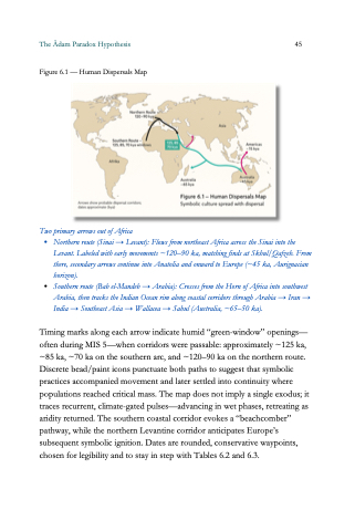
Figure 6.1 — Human Dispersals Map
Two primary arrows out of Africa
Northern route (Sinai → Levant): Flows from northeast Africa across the Sinai into the
Levant. Labeled with early movements ~120–90 ka, matching finds at Skhul/Qafzeh. From
there, secondary arrows continue into Anatolia and onward to Europe (~45 ka, Aurignacian
horizon).
Southern route (Bab el-Mandeb → Arabia): Crosses from the Horn of Africa into southwest
Arabia, then tracks the Indian Ocean rim along coastal corridors through Arabia → Iran →
India → Southeast Asia → Wallacea → Sahul (Australia,
~65–50 ka).
Timing marks along each arrow indicate humid “green-window
” openings—
often during MIS 5—when corridors were passable: approximately ~125 ka,
~85 ka,
~70 ka on the southern arc, and ~120–90 ka on the northern route.
Discrete bead/paint icons punctuate both paths to suggest that symbolic
practices accompanied movement and later settled into continuity where
populations reached critical mass. The map does not imply a single exodus; it
traces recurrent, climate-gated pulses—advancing in wet phases, retreating as
aridity returned. The southern coastal corridor evokes a “beachcomber”
pathway, while the northern Levantine corridor anticipates Europe’s
subsequent symbolic ignition. Dates are rounded, conservative waypoints,
chosen for legibility and to stay in step with Tables 6.2 and 6.3.
