
Page 223 - Green - Maritime Archaeology: A Technical Handbook. 2nd ed
P. 223
202 Maritime Archaeology: A Technical Handbook, Second Edition C. RHINO
The three-dimensional package, Rhinoceros, a NURBS 3D modelling program, was used to plot all artefacts on the site and Matthews carried out this work. Rhino is a very sophisticated, yet easy to use, program, and a complete three-dimensional site plan was produced with this system.
The program has the usual four-window format: plan, front, side and perspective views (although other views can be chosen, i.e. bottom). A wire-frame model of each type of amphora (and various other objects) was generated, usually from a photograph of the object itself. To keep the file size small, a generic example of each artefact type was made. The outline of the object is produced and then rotated around the vertical axis to produce a solid wire-frame object and then scaled. The handles are gener- ated separately and added or “attached” to the main body of the amphora. Additionally, the three target points on the mapping labels are then added. Other artefacts were generated in a similar way, although only the amphorae had the mapping label arrangement. For the small objects, they were either placed in their approximate position, or two or three selected points were measured on the object and used to locate its position.
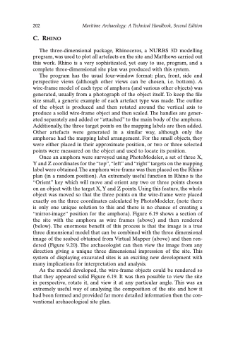
Once an amphora were surveyed using PhotoModeler, a set of three X, Y and Z coordinates for the “top”, “left” and “right” targets on the mapping label were obtained. The amphora wire-frame was then placed on the Rhino plan (in a random position). An extremely useful function in Rhino is the “Orient” key which will move and orient any two or three points chosen on an object with the target X, Y and Z points. Using this feature, the whole object was moved so that the three points on the wire-frame were placed exactly on the three coordinates calculated by PhotoModeler, (note there is only one unique solution to this and there is no chance of creating a “mirror-image” position for the amphora). Figure 6.19 shows a section of the site with the amphora as wire frames (above) and then rendered (below). The enormous benefit of this process is that the image is a true three dimensional model that can be combined with the three dimensional image of the seabed obtained from Virtual Mapper (above) and then ren- dered (Figure 9.20). The archaeologist can then view the image from any direction giving a unique three dimensional impression of the site. This system of displaying excavated sites is an exciting new development with many implications for interpretation and analysis.
As the model developed, the wire-frame objects could be rendered so that they appeared solid Figure 6.19. It was then possible to view the site in perspective, rotate it, and view it at any particular angle. This was an extremely useful way of analysing the composition of the site and how it had been formed and provided far more detailed information then the con- ventional archaeological site plan.
