
Page 46 - Green - Maritime Archaeology: A Technical Handbook. 2nd ed
P. 46
Chapter 3: Search and Survey 25
House chimney
Pine tree
Church spire
Left-hand transit
Right-hand transit
Lighthouse
Position of vessel
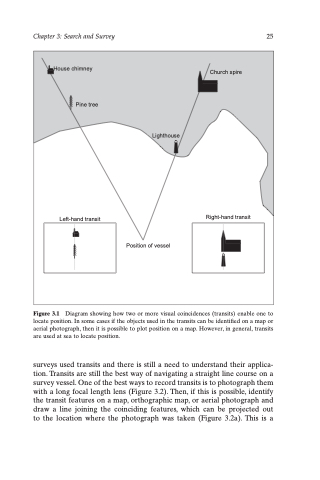
Figure 3.1 Diagram showing how two or more visual coincidences (transits) enable one to locate position. In some cases if the objects used in the transits can be identified on a map or aerial photograph, then it is possible to plot position on a map. However, in general, transits are used at sea to locate position.
surveys used transits and there is still a need to understand their applica- tion. Transits are still the best way of navigating a straight line course on a survey vessel. One of the best ways to record transits is to photograph them with a long focal length lens (Figure 3.2). Then, if this is possible, identify the transit features on a map, orthographic map, or aerial photograph and draw a line joining the coinciding features, which can be projected out to the location where the photograph was taken (Figure 3.2a). This is a
